Start: Twin Lakes – 6.5 End: Roaring River – 21.5 Miles: 15.0 Start: 6:53 am End: 3:44 pm
Day 3
Start: Roaring River – 21.5 End: Colby Lake – 31.5 Miles: 10.0 Start: 7:06 am End: 2:45 pm
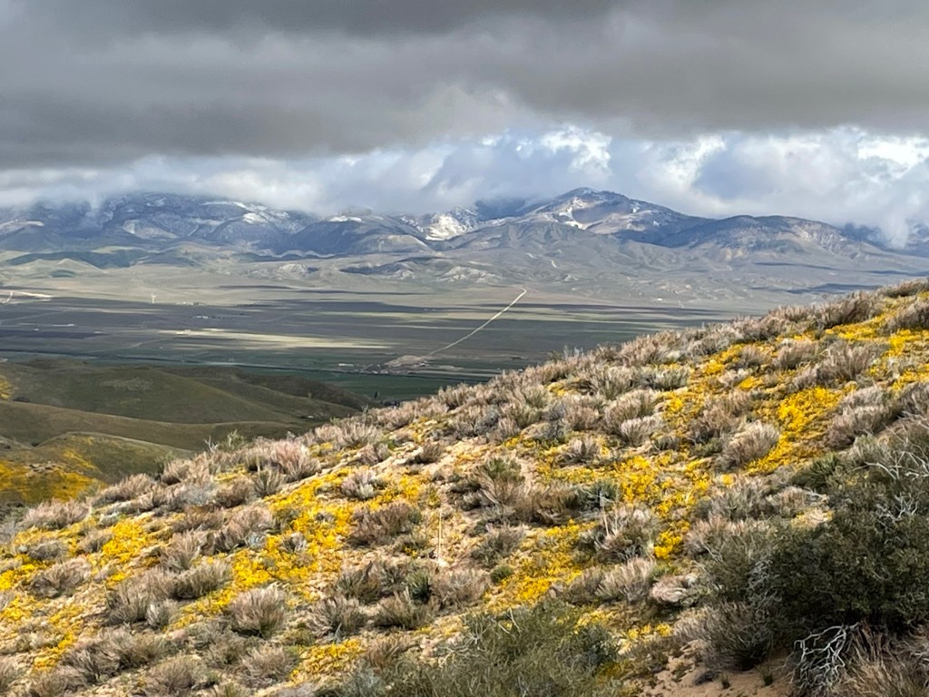
Current elevation: 10,607’
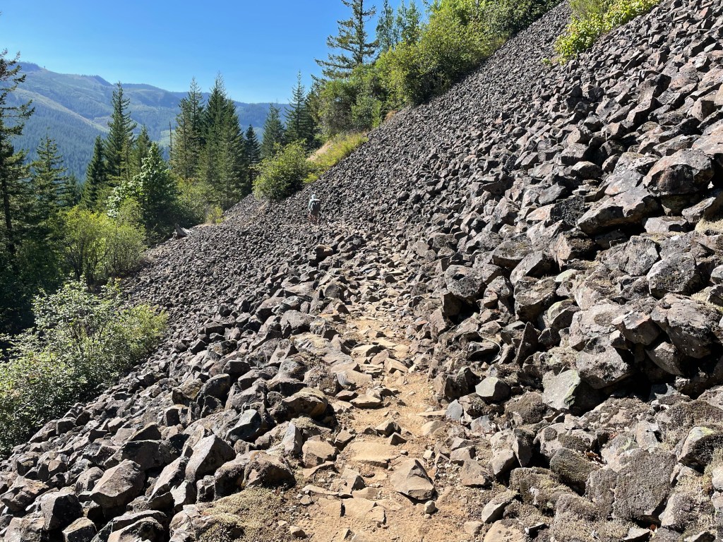
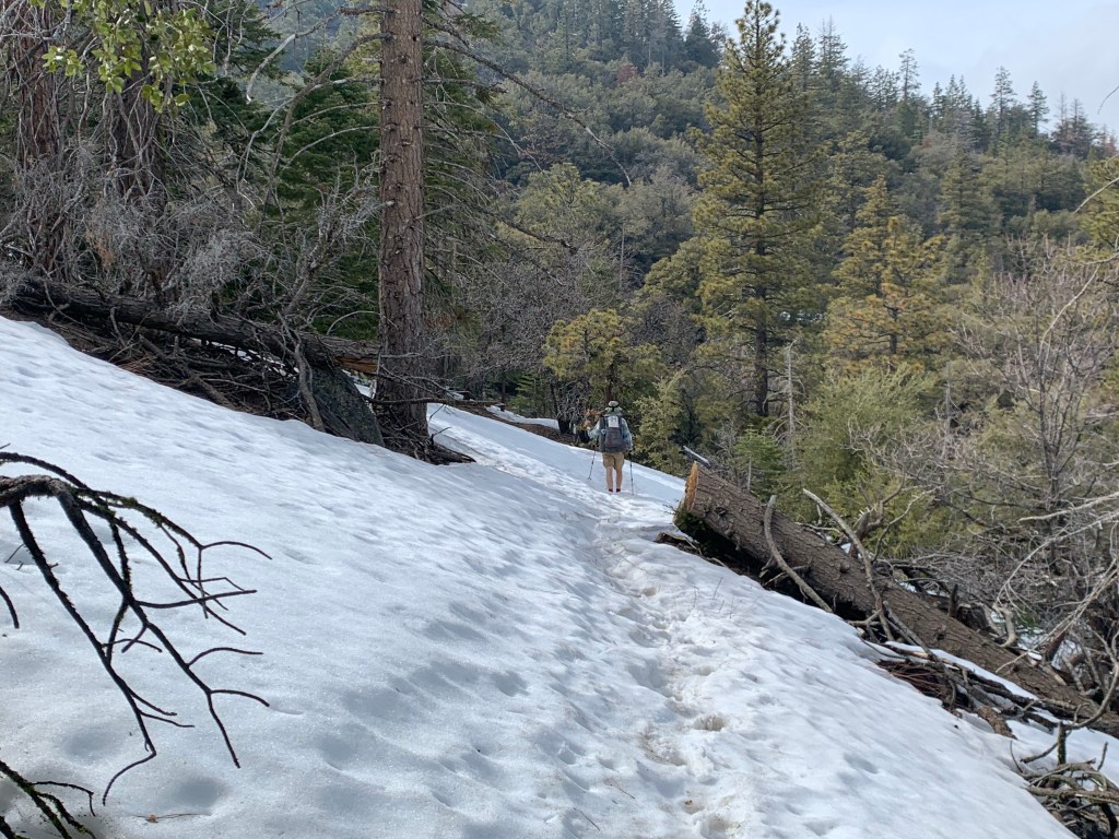
Sierra miles are a lot different than other trail miles. Lots of rocks, steps when going up or down. It took us almost 8 hours to go 10 miles. The last 2 miles took over 2 hours.
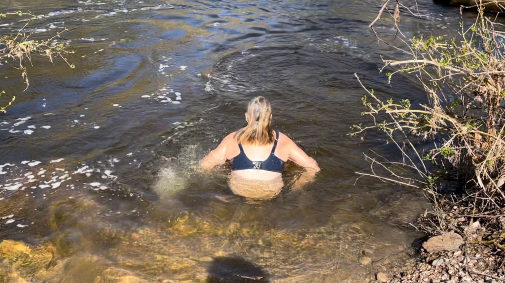
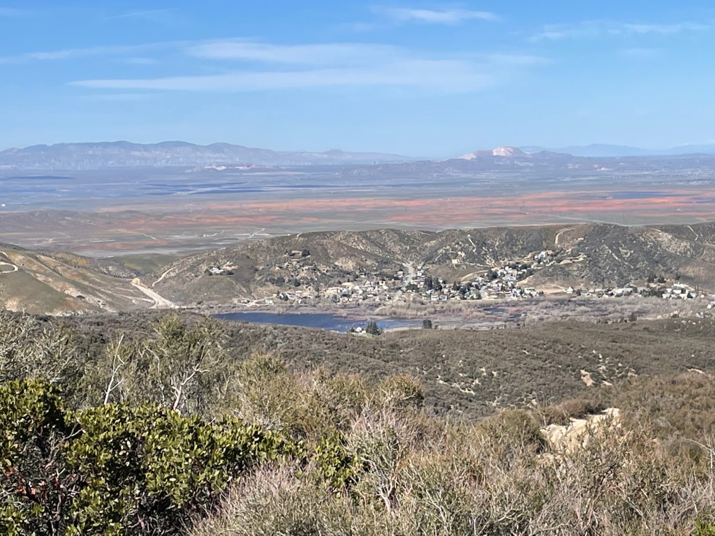
Colby lake is beautiful. Water was good for swimming. Wish we had a fishing pole. Lots of decent size trout swimming about.
Day 4
Start: Colby Lake – 31.5 End: Kern Hot Springs – 48.0 Miles: 16.5 Start: 6:51 am End: 6:25 pm
What a long day. Again, never underestimate the trails in the Sierra! Once over Colby Pass, it took us forever to get to junction meadows. We did about 8.5 miles in 8 hours. It was slow going. Rocky terrain and the last 3 miles the trial was totally overgrown.
Day 5
Start: Kern Hot Springs – 48.0 End: below Kaweah Gap – 65.0 Miles: 17.0 Start: 6:45 am End: 5:29 pm Current elevation: 10,348’
We found an epic site. In the middle of the mountains. Below Kaweah Gap and Nine Lakes Basin. Views of Triple Divide peak and the Kaweah range peaks.
Day 6
Start: below Kaweah Gap – 65.0 End: Mehrten Creek – 79.0 Miles: 14.0 Start: 7:24 am End: 5:49 pm
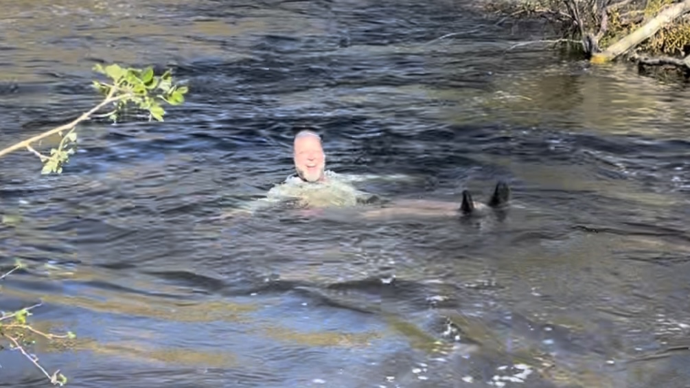
Long day of downhill hiking. We swam in Hamilton lake. Crappy campsite to get to, but we had a spot up high with a view of the mountains. Unfortunately, the smog/dust from the valley caused a brown haze above the mountains. We found out later the haze was from two fires west of us.
Day 7
Start: Mehrten Creek – 79.0 End: Lodgepole CG – 86.5 Miles: 7.5 Start: 7:24 am End: 11:18 am
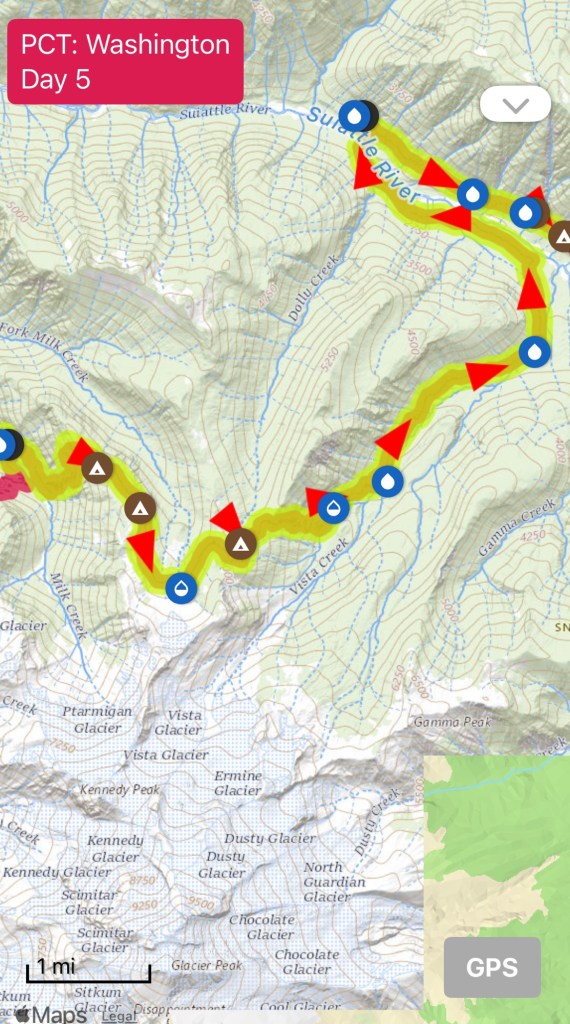
Start: campsite before Kennedy creek – 2514.5 End: Milk Creek – 2527.7 Miles: 13.2 Start: 6:21 am End: 4:00 pm
Day 5
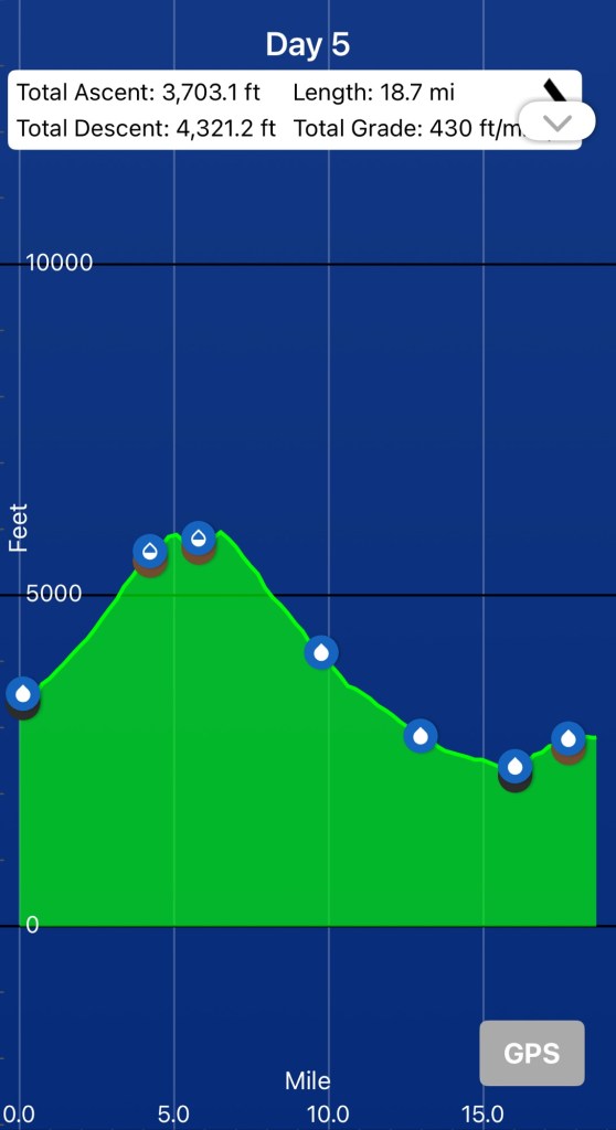
Start: Milk Creek – 2527.7 End: near Miner Creek – 2546.4 Miles: 18.7 Start: 6:27 am End: 6:04 pm
Day 6
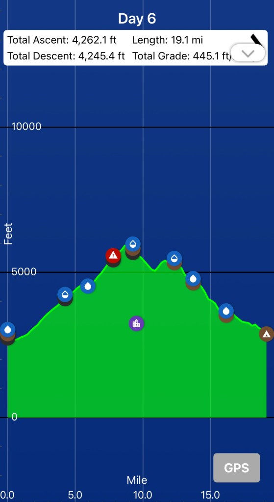
Start: near Miner Creek – 2546.4 End: Cedar Camp – 2565.5 Miles: 19.1 Start: 6:24 am End: 5:12 pm
Day 7
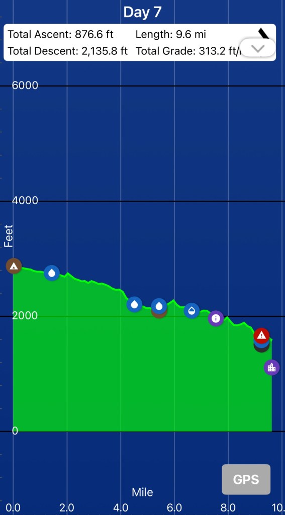
Start: Cedar Camp – 2565.5 End: High Bridge/Stehekin – 2575.1 Miles: 9.6 Start: 708 am End: 11:24 am
Upon arrival at High bridge we waited for the blue bus to take us to the Stehekin Pastry Company and then to the Stehekin lodge/restaurant. We decided to camp at the group site at Lakeview campground. The next day we took the 12:45 pm ferry back down Lake Chelan to Chelan. Then we took the free bus to Wenatchee.
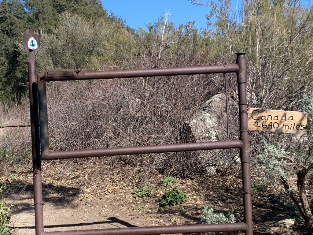
We have now completed 99.2% of the Pacific Crest Trail. the only section missing is the 21 miles from Cajun Pass to Wrightwood in Southern California. It had been closed the two times we’ve tried to hike this section due to wild fires. Ellen considers our thru hike complete. Jeff still wants to get those last 21 miles.
We took a very early flight from Detroit to Seattle. After figuring out the public transportation system we arrived at our hotel in. Belltown. We checked our luggage and proceeded to explore Seattle.
We off course made the walk to the headquarters of REI and walked around their flagship store.
We then got on some electric scooters and made our way to the waterfront. We found the famous Pikes Market.
The next day we got on the Greyhound bus to Stevens Pass to Berlin our hike.
Start: Bridge of the Gods – 2149.5 End: dirt road after climb – 2162.7 Miles: 13.2 Ascent: 4228 ft | Descent: 1186 ft
Start time: 12:14 pm End time: 6:56 pm Current elevation: 2998 ft Total PCT miles: 1425.3
We got a late start hiking today since we had to wait for the mail to show up with All In’s new shoes. Plus we had to walk to the post office ourselves to mail our resupply boxes ahead on the trail.
After breakfast and the post office we took the bus from Hood River back to Cascade Locks. As we got off the bus we saw Sherpa Cheryl and TownStop. They were on their way to Portland to visit Sherpa’s husband and Townstop’s fiancé. We also saw Went by the post office. We enjoyed a quick reunion with him and then started walking to the bridge.
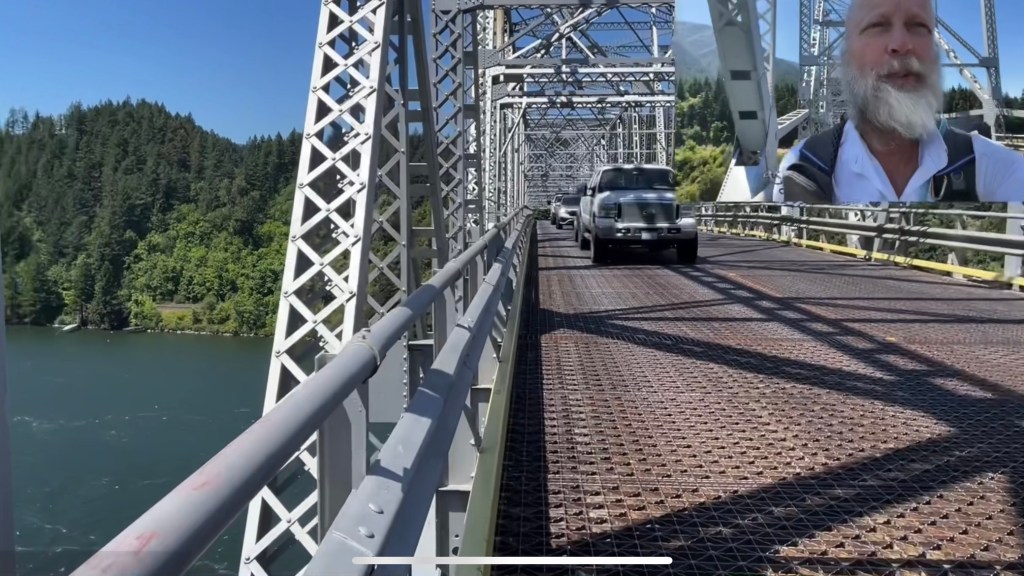
We walked across the bridge and at the midpoint entered Washington … for real this time! It was tight with only a single lane for cars in each direction (and no walkway), but at no time did we feel unsafe. The bridge is a designated part of the PCT. Several cars waved and gave thumbs up to us, seemingly knowing what we’ve been doing these past few months. One vehicle slowed to talk.
We got back on the trail and it was right back into the forest … and up up up! The PCT is at its lowest elevation while crossing the Columbia River and so we had some elevation to regain.
With 10 miles remaining until our intended campsite, we stopped at a small trickle of water. This would be the last water source for the day and into the next morning. Tonight we’ll be dry-camping and so we all carried out 3.5 liters to get us through today’s hike, evening meal, breakfast, and hike out tomorrow morning.
Jeff arrived first at our intended campsite and found three ladies had already set up their tents in one of the many flat areas atop this ridgecrest. One of them came over to visit as Jeff was setting up. They both thought the other looked familiar but did not know from where.
Day 129 – Another 20+ mile day
Start: dirt road after climb – 2162.7 End: Panther creek cg – 2184.7 Miles: 22.0 Ascent: 3631 ft| Descent: 5366 ft
Start time: 6:06 am End time: 4:54 pm Current elevation: 948 ft Total PCT miles: 1447.3
We got up around 5 am and noticed that it was just getting light. Seems weird, but less than a month ago the days were getting longer … now they’re getting shorter. Still, we hit the trail just after 6 am.
First order of business was short steep climb and then back down. The slope of the trail in Washington has been noticeably steeper and today was no exception. Most of the trail was again in forest, aka the green tunnel. However, the foot path was nice and soft with only occasional rocky sections. We found our first water source around 8:30 am and filled up.
Next was a short climb and once at the top we had some cell service. Ellen used this opportunity to check the scores for the Women’s Word Cup!
At lunch time the trail passed adjacent to Rock Creek road (just a two-track through the woods). We found a nice large flat spot in the shade and took our time eating as we had already done over half of our intended miles for the day. Then it was 5.6 miles to next water and 10.5 miles to camp.
It was mostly downhill at this point and still in the green tunnel. We all made quick time of the downhill and within 2 hours we were at the water – Trout Creek. Then it was just 5 miles to Panther Creek forest service campground.
It is nice to sometimes stay at an actual campground with piped water and vault toilets. However, as we walked into the campground we noticed the sign said it was full. It was the weekend and so there were many drive-in campers. Jeff asked a camper for the location of the camp host and the nice lady asked if were PCT hikers in need of a campsite. She then offered us their extra campsite since their friends were no-shows. Later, her husband brought us a beer. People are so nice!
We set up camp, walked down to Panther Creek to wash up, and then had dinner. We were all tired and were in bed before 7 pm. Tomorrow looks like a beast of a day!
Day 130 – Swimming
Start: Panther Creek FS Campground – 2184.7 End: Blue Lake – 2207.9 Miles: 23.2 Ascent: 5950 ft| Descent: 2211 ft
Start time: 6:38 am End time: 5:16 pm Current elevation: 4639 ft Total PCT miles: 1470.5
It was a very quiet night at the Panther Creek campground (thank you campers). We got going after a quick breakfast and then stopped at Panther Creek to filter water. We had a big climb ahead and next water was 10 miles away.
The climb started immediately with 8 switchbacks. In spite of the steep grade we made great time and after less than 2 hours we did 5.1 miles. It was yet another 4.4 miles to the top of Mt. Huckleberry. The trail itself was smooth but steep through the green tunnel. We took a packs-off-break and enjoyed a view of Mt. Hood, now far to the south.
The trail proceeded downhill now and we anticipated an off-trail spring rumored to still have a trickle of water. We found the side trail and Jeff went down to fill both of our cnoc bags. A half mile later we stopped to have lunch. We had done 13.2 miles and it was only 12:15 pm. It was 10.1 more miles to Blue Lake, our intended campsite for the night.
It was now mid afternoon and it was hot. We went through an area with lots of ponds and now the mosquitoes were back. They were tiny though and not as aggressive as the skeeters in Oregon.
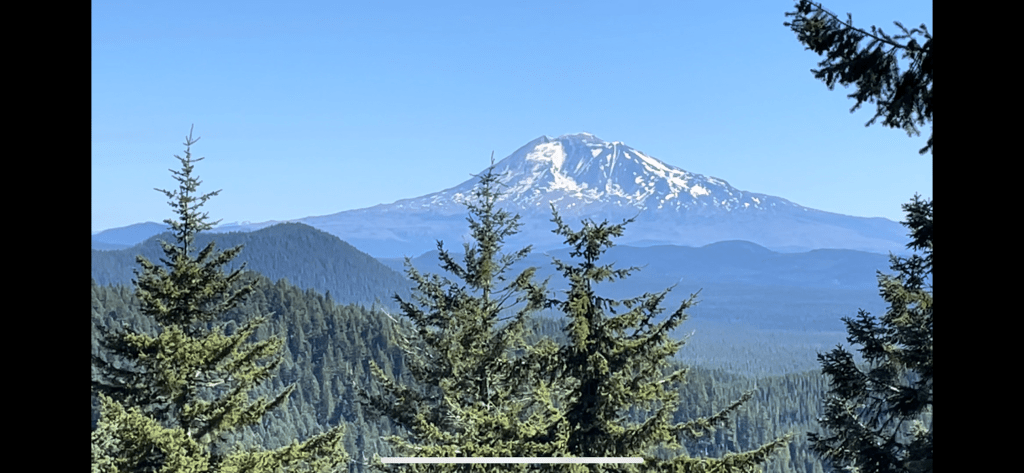
As we crested a ridge, we had a view of Mt. St. Helens on the west and Mt. Adams on the east.
As is always the case, the last couple of miles of the day always take forever. We had to do one more set of uphill switchbacks and then it was downhill with another uphill bump.
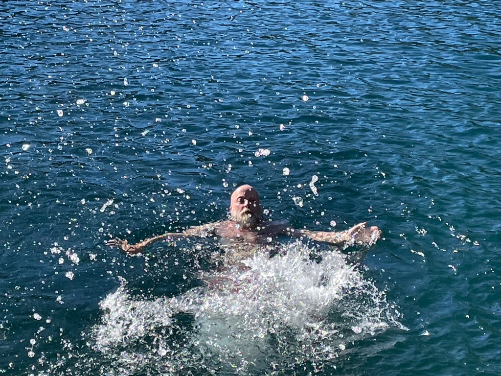
We made it to gorgeous Blue Lake with enough daylight and sun to go for a swim. The water was really clear and the shore had a rocky platform to jump off. It get great to rinse off after a hot and sweaty day of climbing. We had our biggest day of climbing, almost 6000 ft.
The same three ladies camped on the ridge two nights ago were also now camped here at Blue Lake.
As we were eating dinner, the woman Jeff was speaking with two nights ago asked if Ellen was “Ellen”. Ellen then immediately recognized the hiker as “Onward”, a female hiker about our age. I guess our appearances have changed a lot since starting this hike! We met Onward way back in March in the Southern California desert and had since loosely kept in contact. It was great catching up with her and hopefully we’ll be able to hike together again.
Onward & TakeCharge
Blue Lake was popular and the campsite was full with 8 tents. We would not say the trail is “crowded” but we are now competing for campsites with southbound PCT hikers who started from the northern terminus in July. Remaining northbound PCT hikers are also now concentrated in Oregon and Washington, having skipped over the Sierras. Of course there are also weekend and section hikers on trail. However, if there is a flat spot available, everyone is willing to share.
Day 131 – Our personal best!
Start: Blue Lake – 2207.9 End: Trout Lake rd – 2231.6 Miles: 23.7 Ascent: 3071 ft| Descent: 3766 ft
Start time: 6:08 am End time: 3:36 pm Current elevation in Trout Lake: 1896 ft Total PCT miles: 1494.2
We woke up at 4:45am, packed our gear, and had a quick breakfast. We had plans to hike almost 24 miles to a forest service road and catch the shuttle to the town of Trout Lake by 4:30 pm.
We got to walking just after 6 am and did our morning video by the lake. The early morning hike was nice. We actually got some really cool views of Mt. Adams and one distant view of Mt. St. Helens. After that it was back to the green tunnel. We also saw a bit of snow. No, not that white stuff again! We also hiked along the edge of a very ancient lava flow.
By 10 am we had hiked 10 miles, a so called “10 by 10”. There were some climbs and descents but the trail was really nice and smooth and this makes for really fast hiking.
We crossed a forest road and saw All In sitting down and having a snack. As we passed we yelled “20 by 2!”, implying that our goal was 20 miles by 2 pm. We kept hiking to the next water source and around 11:30 am we decided to have a quick lunch. All In came hiking by really fast and said the “20 by 2” really got him motivated.
We were both calculating time and distance to the road in our heads and we kept our lunch break to only 15 minutes. Trying to finish off our remaining food, Jeff’s lunch included almost half a can of spam on a tortilla.
We actually did 20 miles in 8 hours including lunch and other short breaks. It really helped that the hike was all in the green tunnel and there were no views to be distracted. We were pretty proud of ourselves. The last 1.3 miles was up hill and we still had another 3.6 miles to get to the road. The last 2.3 miles was all steep downhill but we made quick time of the miles and at 3:35 pm we were at the road for the shuttle pickup.
At some point this afternoon, we heard an animal which we did not recognize. It repeatedly barked a sharp “raff, raff, raff” every 10 seconds or so as we passed close by. It sounded almost canine … but not. Later, when Onward arrived at the road, she shared a video clip of the animal we assume had made these noises. It was a beautiful black fox pacing excitedly across the trail in front of her! His coat was jet black except for silver highlights on his back and bright white on the tip of his tail. We did not get a photo but here is an example:
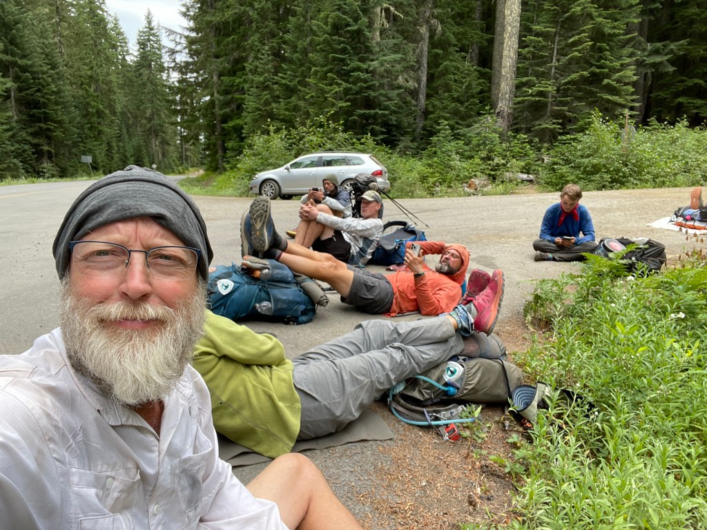
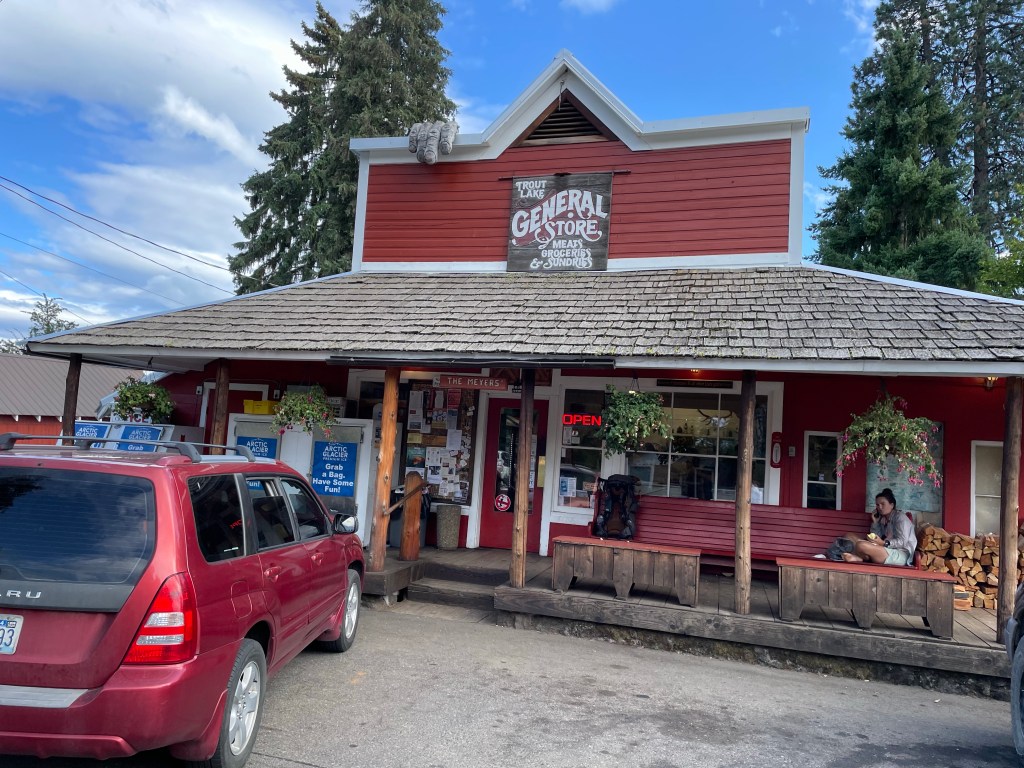
At 4:30 pm the “shuttle” arrived and we all hopped in the truck. The guys were in the bed of the pickup truck with the backpacks while the ladies got to sit inside. Trout Lake is an important resupply point on the PCT and so volunteers from the town send vehicles up the road to the trail at 8am, 12pm, and 4pm each day during hiking season. The drive from the trailhead to town took only 20 minutes. Once there, we retrieved the resupply boxes we had mailed to the general store.
While we at the top of our climb, All In made a call to a Trail Angel and got us rooms at her house with dinner, showers and laundry included. After checking out the grocery store we walked over to Joanna’s place. She showed us around and started making dinner. We all took showers and then did laundry. Joanna has been hosting hikers for a few years.
We had a great dinner and then retreated to our bedrooms to rest and catch up on the outside world. Ellen got to watch some World Cup soccer. It was a great day and it felt good to get clean and sleep in a bed. Thank you Joanna!
Day 132 – Back to work
Start: Trout Lake rd – 2231.6 End: Riley’s Creek – 2241.8 Miles: 10.2 Ascent: 2466 ft| Descent: 570 ft
Start time: 12:27 pm End time: 4:57 pm Current elevation: 5772 ft Total PCT miles: 1504.4
We had a restful evening. We are actually quite comfortable sleeping in the tent on our air mattresses and sometimes more so than a bed. But it is always very nice to have a roof over our heads and all the conveniences of modern life.
We went to breakfast at the local cafe and then to the grocery store for some resupply items. The store did a great job with stocking up on hiker specific foods. After the store we went back to Joanna’s to pack our food and other gear. We then just hung out until 11 am when the taco truck opened.
We had visions of really yummy food from the taco truck but the food was rather bland. We guess we’re used to spicy foods. After our lunch we went caught the 12 pm shuttle back to the trail.
Neither of us were really in the mood to go for a hike as we all had full stomachs and we were tired. But we had miles to hike so off we went. The first few miles were a climb through the forest, of course.
Then after 5.8 miles for the day we hit our personal 1500 mile mark. We can’t believe we’ve walked 1500 miles! Unfortunately, we didn’t do any kind of celebration.
We continued to walk on a traverse facing west in a burned area. This allowed us to have some views to the west of Mt. St. Helen and other distance mountains. It was really nice to have something else to look at besides trees and bushes.
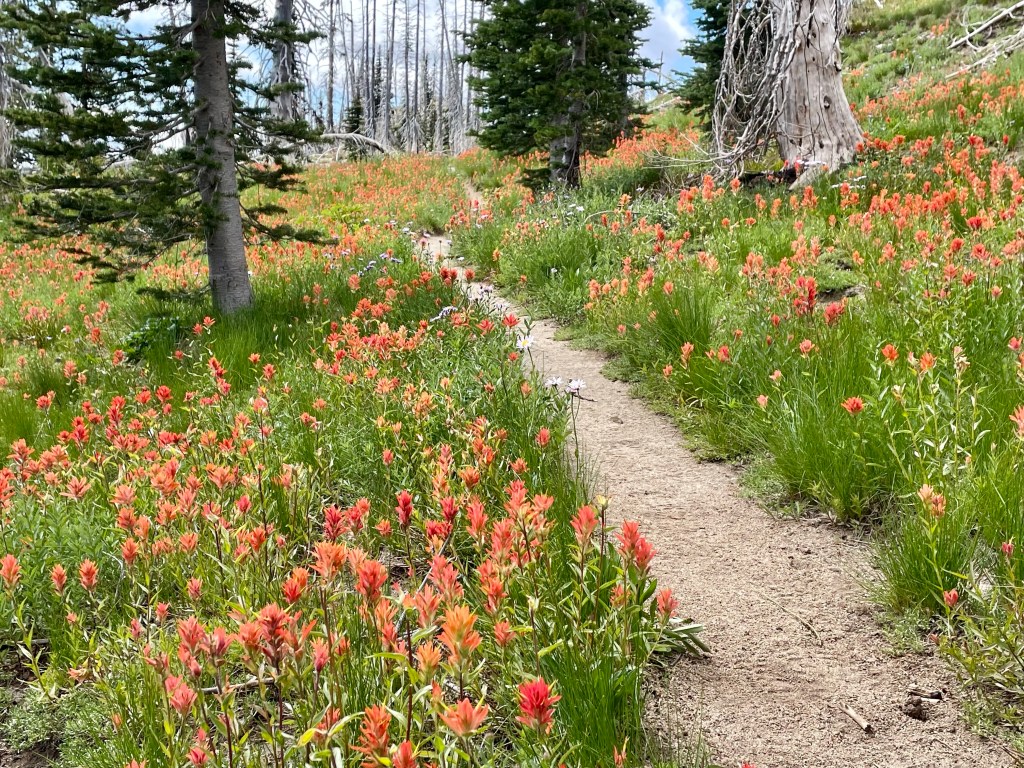
We also hiked through several meadows with lots of wildflowers that we’ve seen before in alpine settings.
Mt Adam’sMt St Helen’sIndian Paintbrush
We made it to Riley Creek after 10.2 miles and just before 5 pm. Not a long or big day in terms of miles but we were still all tired. Hopefully tomorrow we’ll hike some better and bigger miles as the terrain looks favorable.
We were camped in a meadow below Mt. Adams and next to Riley Creek. The creek was glacial melt from Pinnacle Glacier on Mt. Adams. The water was not too silty as it typical for glacial streams. We had one of the levelest and flattest spots since we started this trail. It sure beat the tree root that was under our tent two nights ago at Blue Lake.
Day 133 – Big miles again
Start: Riley’s Creek – 2241.8 End: Walupt creek – 2267.3 Miles: 25.5 Ascent: 2885 ft| Descent: 3618 ft
Start time: 6:11 am End time: 5:47 pm Current elevation: 4933 ft Total PCT miles: 1529.9
We woke up to frost on our tent. We didn’t realize it would get that cold! But it did make sense since we were in a low valley next to a creek.
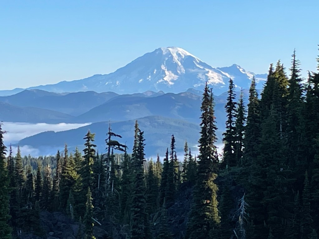
The day started out beautiful. As we went up the little trail from our valley campsite, Mt. Adams was looking sharp. After a few minutes we rounded a corner and saw Mt. Rainer in the distance with the valley below socked in with low clouds.
About an hour later we crossed one of several lava fields. Then it was time to cross Adams creek, a glacial creek from Adams Glacier on Mt. Adams. All In decided to use a log to cross and promptly slipped on the slippery log. No harm, only one foot wet. We decided to go upstream a little bit and just wade through at a safe spot.
The trail then went back into the forest. A couple hours later the trail followed the border of the Yakima Indian Reservation. The trail was very straight and exposed to the sun. At one point there was a giant lava wall next to the trail.
The rest of the afternoon was very uneventful. The trail again was in the forest and the green tunnel was back. Once in a while we got a glimpse of Mt. Rainier and the Goat Rocks Mountains ahead.
After 25.5 miles we made camp by a trail junction and by a pond for water. We had decided to push the miles today so that tomorrow we can take our time hiking along the Knifes Edge trail in the Goat Rocks Wilderness. The Knifes Edge is often said to be one of the most spectacular sections on the PCT.
Day 45 – Trail Names Start: hwy 18 Big Bear – 266.1 End: Little Bear trail camp – 285.6 Miles: 19.5 Ascent: 2400 ft| Descent: 2775 ft Start time: 8:55 am End time: 6:40 pm Current elevation : 6862 ft
Since we are a couple, Kenny gave us the “Princess Room” with a private bath. Very nice. We got to sleep-in a little since we weren’t going back to the trail until after breakfast. Kenny was up early making breakfast for everyone: bacon, eggs, potatoes, sausage, and waffles. Kenny has a yearly contest on which hiker makes the best fruit salad. He kept asking if anyone wanted to make fruit salad and no one jumped. Finally Ellen decided that having some fruit with breakfast sounded good. With the help of Jeff, we put a basic fruit salad together and then Jeff made the scrambled eggs.
That brings us to Ellen’s new trail name. The night before during dinner, Ellen took the lead in making sure there was enough money for the waitress since they didn’t do separate checks for nine people. Then at breakfast she again took over in the kitchen. So, she was gifted a trail name of “Take Charge” or “TC” for short.
Jeff’s trail name is “Jelly” which is derived from his corporate ID at Ford Motor Company and also a name gifted by a young scout while on a hike during summer camp last year.
After breakfast Kenny took five of us back to trail. We did our morning video with the group and off we went. The first couple of hours went really fast as the trail was smooth and slowly downhill. Our goal was a water source about 17 miles away.
As the afternoon went on we got a beautiful view of Big Bear Lake with the snowy mountains. We also had cell reception and decided to make some calls. As we were both talking on the phone we totally missed the sharp right turn for the trail and ended up in a side trail with a bunch of day hikers. We realized our mistake and turned around. We lost a half hour of hiking while being distracted when on the phone. Lesson learned!
The plan was to camp near a water source, however there were no flat spots for campsites. We decided to go an extra 2.2 miles to Little Bear camp. We finally got to camp around 6:45 pm. Seems late but it was still a 10 hour day. We just started two hours later than usual.
We did 19.5 trails miles plus our half mile detour. This makes another 20 mile day!
Day 46 – Swimming
Start: Little Bear trail camp – 285.6 End: Deep creek by FS road- 301.3 Miles: 15.7 Ascent: 930 ft| Descent: 3185 ft Start time: 7:12 am End time: 4:01 pm Current elevation: 4230 ft
We got up at our usual time of around 5:30 am. We made a tentative plan with Commander (Jack) to make next camp around 15-16 miles out.
The trail followed Holcomb creek with several crossings that were about knee deep. The trail was easy and by noon we had done almost 10 miles. We had lunch at the last water source of Holcomb creek.
The afternoon dragged on as we had left the forest and were now in the high desert with thorny shrubs alongside the trail. There were also many trees blown down from the harsh winter.
We got a nice surprise when we crossed the bridge over Deep creek. The canyon was beautiful. Deep creek was really flowing hard from all the snow melt.
We also hit another milestone: 500 miles hiked on the PCT! After flipping north we had hiked 200 miles from Aqua Dulce to Walker pass. So, as we now passed the official 300 Mile PCT post, we did a little dance to celebrate our 500 mile trek.
A few miles later we made it to our campsite. It was early enough that we both took a swim in Deep Creek. The water was very cold but really refreshing. Our first swim on this trail!
Day 47 – Hot Springs
Start: Deep creek by FS rd – 301.3 End: Grass valley creek – 318.0 Miles: 16.7 Ascent: 1965 ft| Descent: 2789 ft Start time: 7:02 am End time 4:01 pm Current elevation: 3312 ft
Not sure what it was but both of us had the best nights sleep yet on trail. We got going as usual around 7 am. The plan was to do about 16 or so miles to set us up for two relatively easy days into Cajon Pass.
After less than three hours we made it to Deep Creek Hot Springs, a naturally flowing hot springs that flows into Deep Creek. There were about 20 other hikers there and we took turns sitting in the rock basins which had been constructed to contain the hot water. It was really nice and we spent over a hour at the springs. By 11 o’clock it was time to go if we were going to make our miles for the day.
The deep canyon slowly started to widen and after 6 miles we were at the Mojave River Forks Dam. After taking lunch, we forded Deep Creek.
We then had 4.5 miles until our campsite for the night. We made quick work of the distance and made it there at 4 pm. But, the trail gave us one more surprise as we had to cross Grass Valley Creek first and get our feet wet again right before camp.
We had made camp relatively early and so we spent the rest of the afternoon relaxing, making phone calls since we had cell service and also chatting with Commander.
Day 48 – Easy Peazy
Start: Grass Valley Creek – 318.0. End: Seasonal creek – 335.7 Miles: 17.7 Ascent: 2418 ft| Descent: 2177 ft Start time: 7:08 am End time: 3:45 pm Current elevation: 3579 ft
Wow, what a night! Our sleep was frequently interrupted as the wind was howling all night and pulling out some tent stakes. Eventually 5:30 am came and it was time to get moving.
Nothing really spectacular occurred today. We wanted to get as close to Cajon pass as possible to make the next day an easy hike to McDonalds. The terrain was nice and easy going.
At one point we came around a corner and we’re faced with a giant rock wall of the Silverwood Lake Dam. It was pretty impressive. The next 5 miles took us around the edge of the lake and then west over a highway.
We had a small climb before the final decent to our campsite. We made great time all day and before 4 pm we were done for the day.
It was 9 hours of hiking over 17.7 miles but it was easy physically as the trail was mostly flat and gradual downhill. We had dinner at the commander’s site talking and visiting. It was a pleasant day!
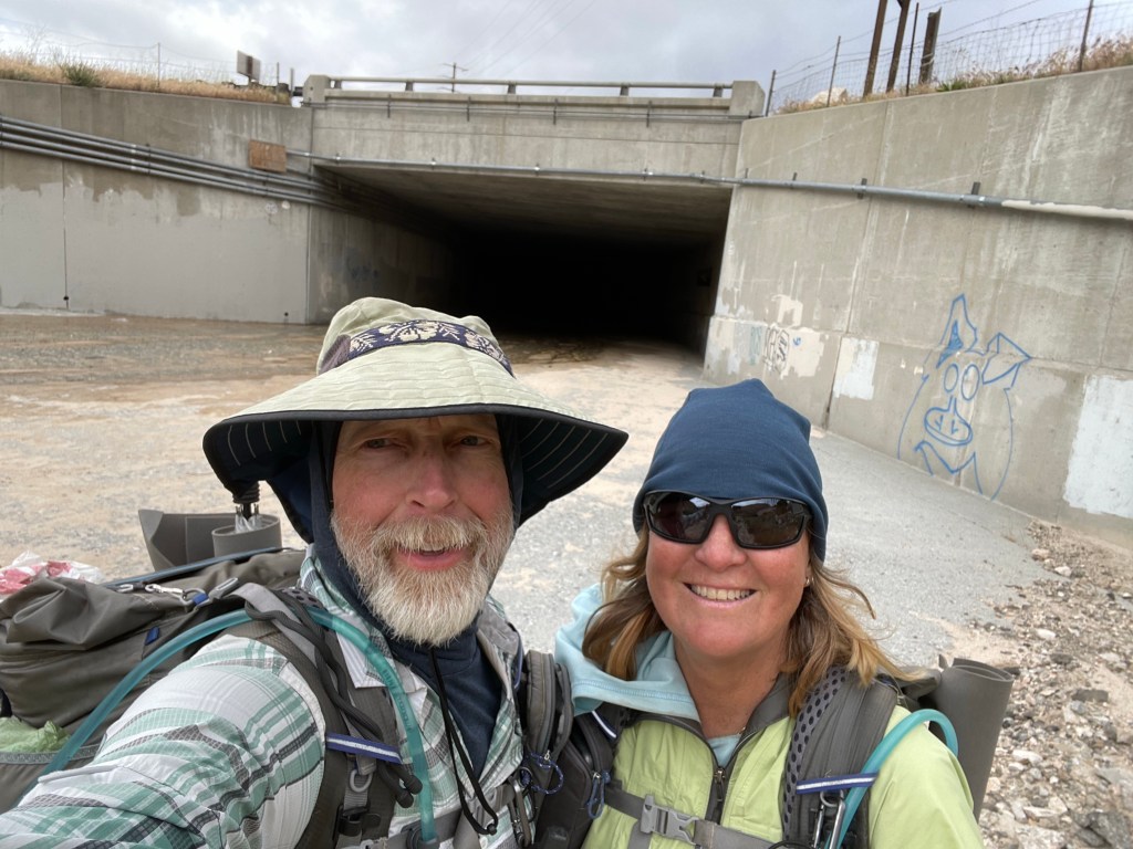
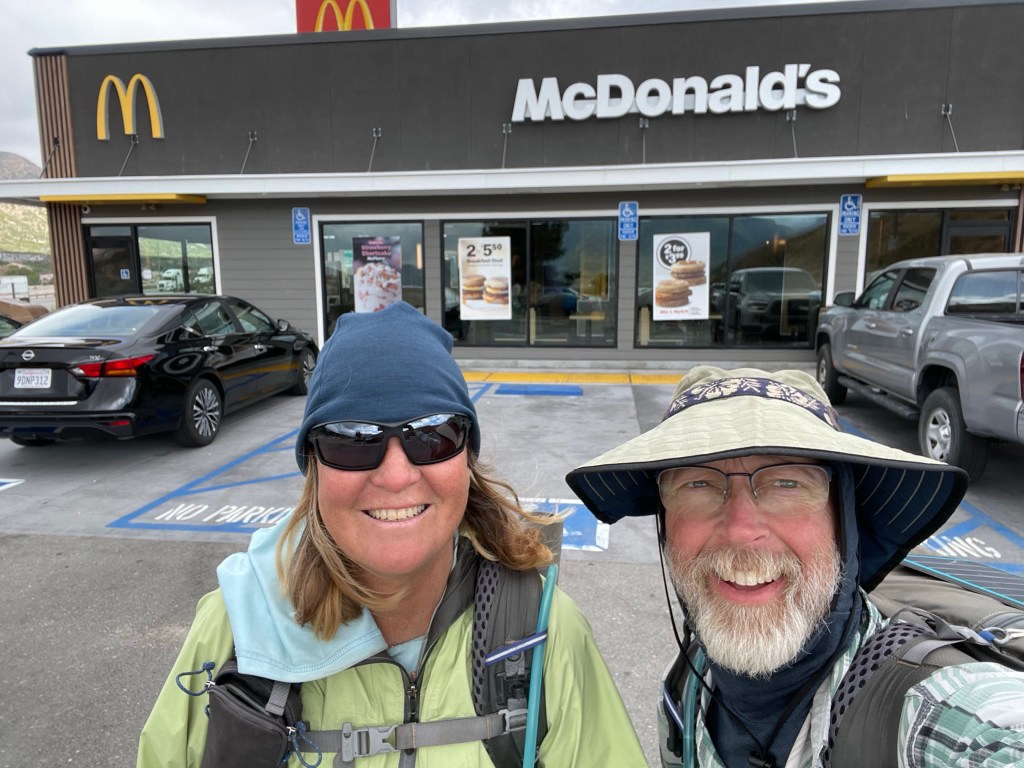
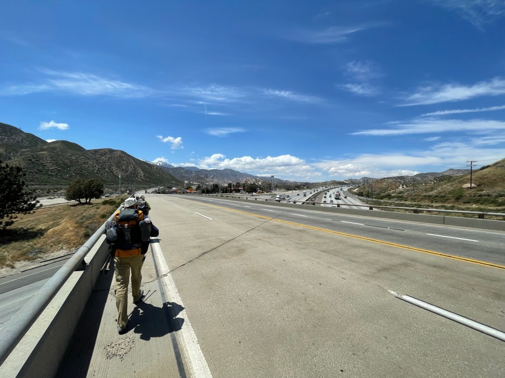
Day 49 – McDonalds! Start: Seasonal creek – 335.7 End: I-15 – 342.0 Miles: 6.3 Ascent: 714 ft| Descent: 1236 ft
Start time: 6:40 am End time: 9:12 am Current elevation: 3146 ft
We hit the trail a bit earlier than usual with McDonals on the mind. Yes, McDonalds … it is a PCT hiker’s right of passage to go to the Cajon Pass McDonalds and consume a great deal of food.
We woke up to stormy looking skies to the south of us. We only had 6.3 miles to go and the trail was super easy as it wound its way down through the eroded hills, low vegetation, and flowers. It continued to be windy most of the morning.
Once at the freeway we decided to walk thru the freeway tunnel and then back again. The next 19 miles of the trail (between Cajon and Wrightwood) was officially closed due to a “controlled burn” that went uncontrolled last week.
So, our final destination for the day was only a 10 minute walk. We got to McDonalds around 9:25 am and saw a few hikers we had been leapfrogging with over the last few days.
We promptly ordered breakfast – lots of it. We sat around with the other hikers, chatting and discussing options on how to get to Wrightwood.
We originally planned to road walk to Wrightwood until we found out it was entirely asphalt – a hiker’s worst nightmare. More discussions and options ensued and before we knew it, it was lunch time. More food!
After a four hour stay at McDonalds, we walked down the road to the Cajon Pass Inn. We secured a ride for tomorrow to Wrightwood. As this is an official fire closure, walking a road or hiking an alternate trail (when available) is considered optional.
At the hotel we worked on our videos and blogs and some other logistics for getting back to Costa Mesa on Friday for Ellen’s father’s wedding. We continue to enjoy the trail and the hiker life.
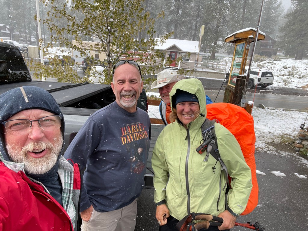
Day 50 – Its snowing in May! Start: I-15 – 342.0 End: Wrightwood – 342.0 Miles: 0.0
Today ended up being another zero, but this time in Wrightwood. We got a ride from Brian from Cajon pass to Wrightwood. The plan was to hike up a side trail to the PCT. Then hike about 7 miles of the PCT and get back to town.
However, after our visit to Mountain Hardware – a must stop for any PCT hiker, it was snowing again. A storm was going thru and already dumped several inches of snow in town and who knows how much up on the mountain ridge. Ellen has been fighting a cold or something and was not up to walking in the cold and wet snow for the day. So we called our hiking buddies All-In and Ryan who had a place. They have been in Wrightwood for several days waiting out the storm.
We ended up staying at one of Arlene’s cottages and hanging out with All-In and Ryan.
In the afternoon Jeff and Ryan decided to go for a hike and check out the conditions on the Acorn trail. This is a trail that connects Wrightwood to the PCT and we had heard conflicting stories on its condition. They came back with a report. It’s doable but it would be better if more of the snow melted on some of the steeply exposed sections. We’ll decide once we get back if we will take this trail.
Days 38, 39 and 40 were zero days as we had to take care of some family matters.
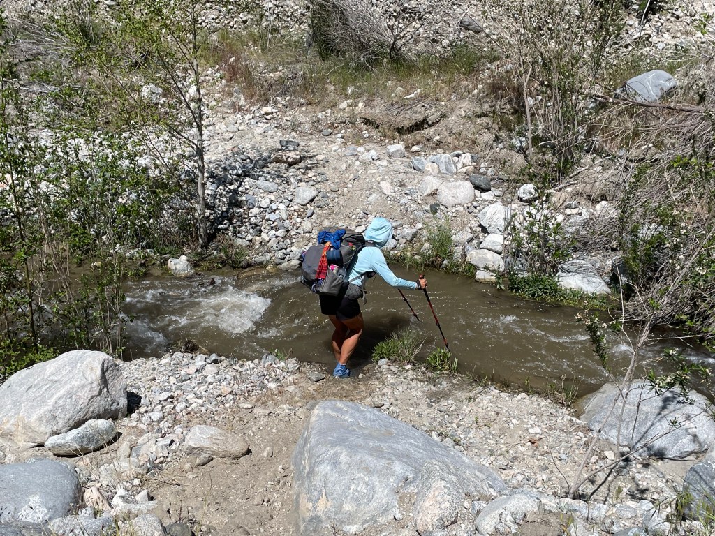
Day 41 – Snakes Start: I-10 underpass – 209.5 End: Whitewater crossing – 220.1 Miles: 10.6 Ascent: 2451 ft| Descent: 1241 ft Start time: 9:35 am End time: 4:15 pm Current elevation: 2568 ft
The night before we got back on trail we spent the night with Ellen’s brother Pete and Debbie. We got up somewhat early to drive 1 1/2 hours back to the I-10 underpass near Cabazon. The drive was easy with only a few minor traffic backups. We arrived at the Enterprise rent a car around 8:30 am. We then waited until they had a driver to drive us back to the trailhead. Around 9:30 am we were back on trail! Woohoo!
It was already starting to get hot with temps in the 70s. After only an hour we saw our first rattlesnake. Ellen heard the rattle and then jumped and let out a small scream. Luckily it just slithered off into the bushes. Ellen got a photo but only the tail.
After another hour we made it to the wind farm offices and they graciously welcome hikers. We found a gazebo with cold water and promptly took a nap after lunch. We were both feeling sluggish from being off the trail for four days. But after an hour of sitting around we decided we better get going.
It was another 6.7 miles to the Whitewater River crossing. We slowly made our way up and down the hills. After another hour and a half, some hikers in front of us waved at us to warn us that there was a snake just up ahead. Sure enough, a few minutes later Jeff heard the rattle and spotted the curled up rattlesnake under a bush right next to the trail. As soon as we got closer it started rattling. The snake would not give up his shady trail side spot and so we took a wide berth around the snake.
The rest of the afternoon was uneventful as we made our way towards Whitewater River which was was really roaring from all the snow melt.
We got to the crossing and found a really nice flat spot for a tent site. A little bit later a group of six hikers showed up and looking for campsites across the creek. We watched as they looked for a place to cross and took mental notes for our crossing tomorrow. All in all it was a good day. We did the miles we set out to do.
Day 42 – Wet feet day
Start: Whitewater crossing – 220.1 End: tributary of mission creek – 235.4 Miles: 15.3 Ascent: 4499 ft| Descent: 918 ft Start time: 6:28 am End time: 5:02 pm Current elevation: 6076 ft
It was a nice warm evening and night. No need to put electronics and water filter in our sleeping bags.
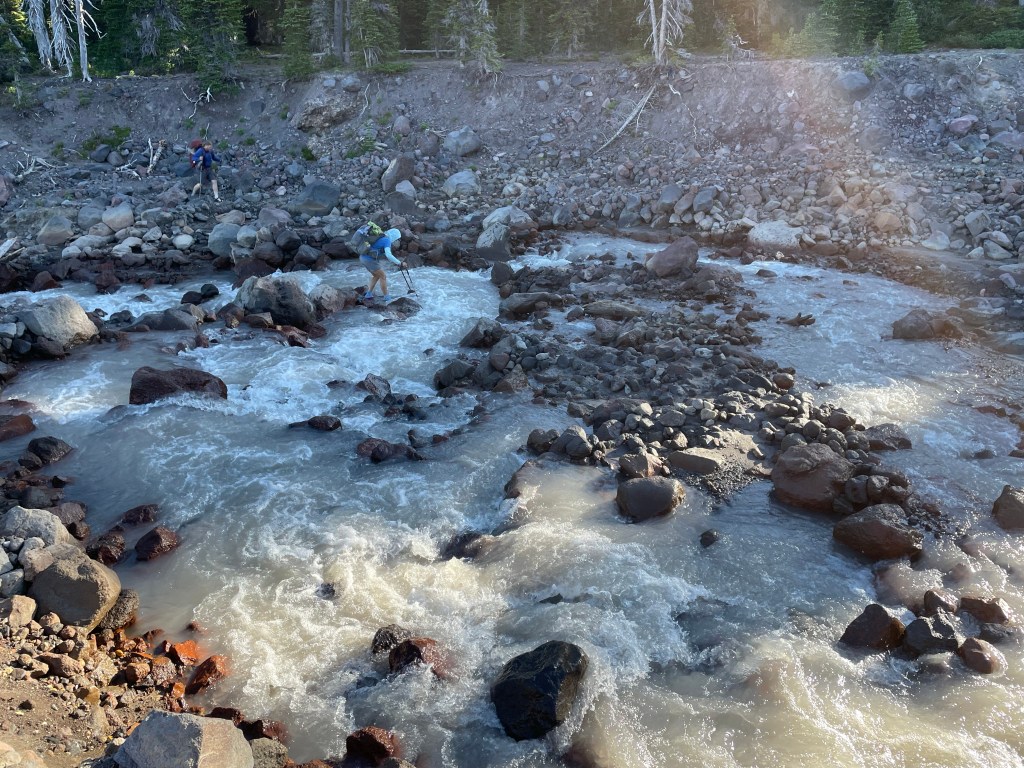
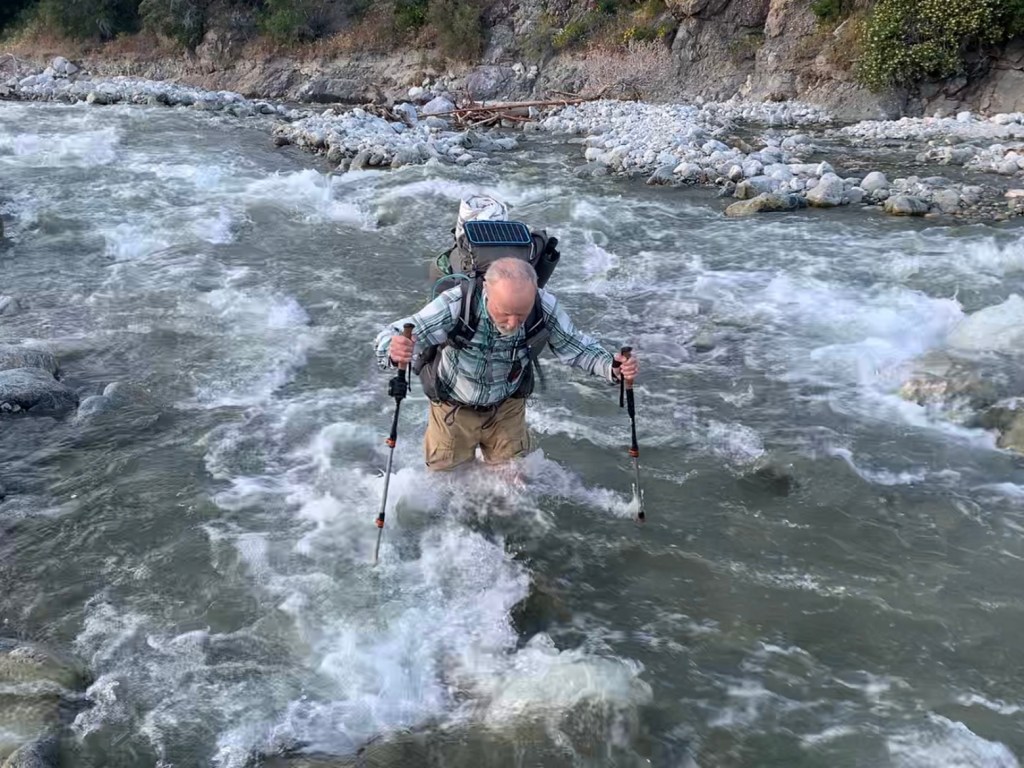
First thing this morning we needed to make the crossing of Whitewater River. It was pretty intimidated but we both took our time and made it safely across. Jeff mentioned that the swift current was rolling a series of boulders the size of bowling balls past his legs as he crossed.
Then it was time to do some climbing. Once out of the Whitewater valley we had to climb over a ridge to get to the Mission Creek valley. The trail was not bad but we did keep our eyes peeled for snakes. No more seen.
Once we got to Mission Creek it was time to follow the creek up the canyon. This included about three dozen crossings. The trail was easy to follow except for a couple times where the creek had washed out the trail earlier in the winter.
At lunchtime we decided to take a 15 minute siesta in the shade. Afterwards it was hard to get going. It was hot in the afternoon climbing up the canyon next to the creek. It actually felt really good to wade across the creek and cool down our feet.
We found a campsite along a tributary of Mission creek. We were both stinky and took advantage of the water and we both took a sponge (bandana) bath. Adhering to Leave No Trace Principles, this does not include soap! Today we had a net elevation gain of about 3500 ft. Tomorrow we are back in the snow.
Day 43 – Back in the snow Start: tributary of mission creek – 235.4 End: top of climb – 248.2 Miles: 12.8 Ascent: 3741 ft| Descent: 1057 ft Start time: 6:59 am End time: 4:13 pm Current elevation: 8748 ft
Neither one of us wanted to get going today. We both did not sleep well and we wanted to sleep a little longer. However, we knew it was time to get up and get some miles in.
The first thing in the morning was a 4.5 mile climb to Mission creek trail camp. It was a long slow climb and took us almost three hours.
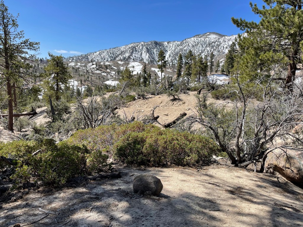
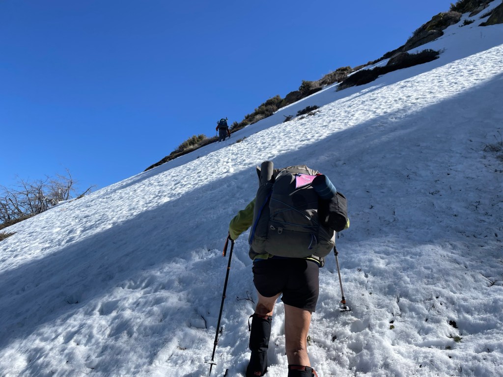
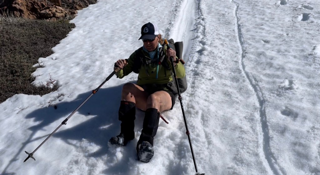
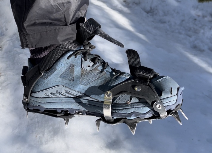
Once finally on top we made the right turn and said goodbye to Mission creek canyon and within a couple miles said hello again to the snow. We put on our micro spikes and made easy work of the less than 2 miles of snow traverses.
Once back on the south side of the mountain it was easy going, but still up. We were told that water was not an issue as there were many streams. Wrong! We got to Coon cabin and Coon Creek was dry. We loaded up our water bags with snow with the hope of melting it as we hiked in the sun.
We got to the top of the climb where there was a campsite. Ellen was totally out of water and Jeff had very little. It was another 8.7 miles to a known spring for our next water. Since there was lots of snow at this campsite, we made the decision to stop a little early and melt snow with the stove for tomorrow’s hike and tonight’s dinner.
We met a few more hikers who also decided to camp at this site. One was a fine gentleman named Jack from Alberta Canada. We didn’t know it at the time, but we would be spending much of the next week with Jack.
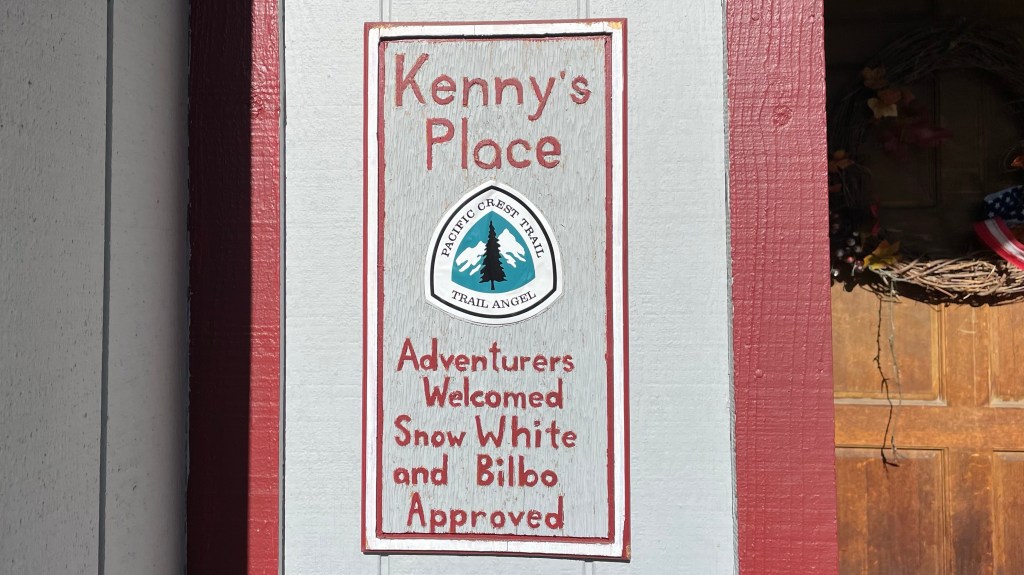
Day 44 – Kenny’s place – Big Bear Lake Start: top of climb – 248.2 End: hwy. 18 Big Bear – 266.1 Miles: 17.9 Ascent: 1887 ft| Descent: 3576 ft Start time: 6:55 am End time: 4:05 pm Current elevation: 6832 ft
We got going after less than an hour from wake up time. We are getting quicker in the mornings. The first mile of the trail we had to deal with some snow fields. Then it was dry trail! Our next known water was about 6 miles away but after only two miles we found a small snow melt stream.
After about another 4 miles we got to Cienaga Seca Creek which was flowing nicely. We took a break, drank lots of water and filled our water bottles. We knew we had some miles until our next water source.
About 10 miles into the day we got to Arastre Creek. We followed the creek for several miles crossing it many times. After so many wet days, we had decided that today would be “Dry Foot Friday”. That meant no walking straight thru the creeks and getting our feet wet.
Most of the afternoon was downhill which was good since it was a long way to the road. We had called Kenny for a ride and a stay at his place earlier in the morning. We now had to somewhat hustle to get to hwy 18 where he was going to pick us up.
When Kenny showed up he also had Jack with him. Kenny took us to his place and he explained that he’s been hosting hikers for about 4 years and he loves it.
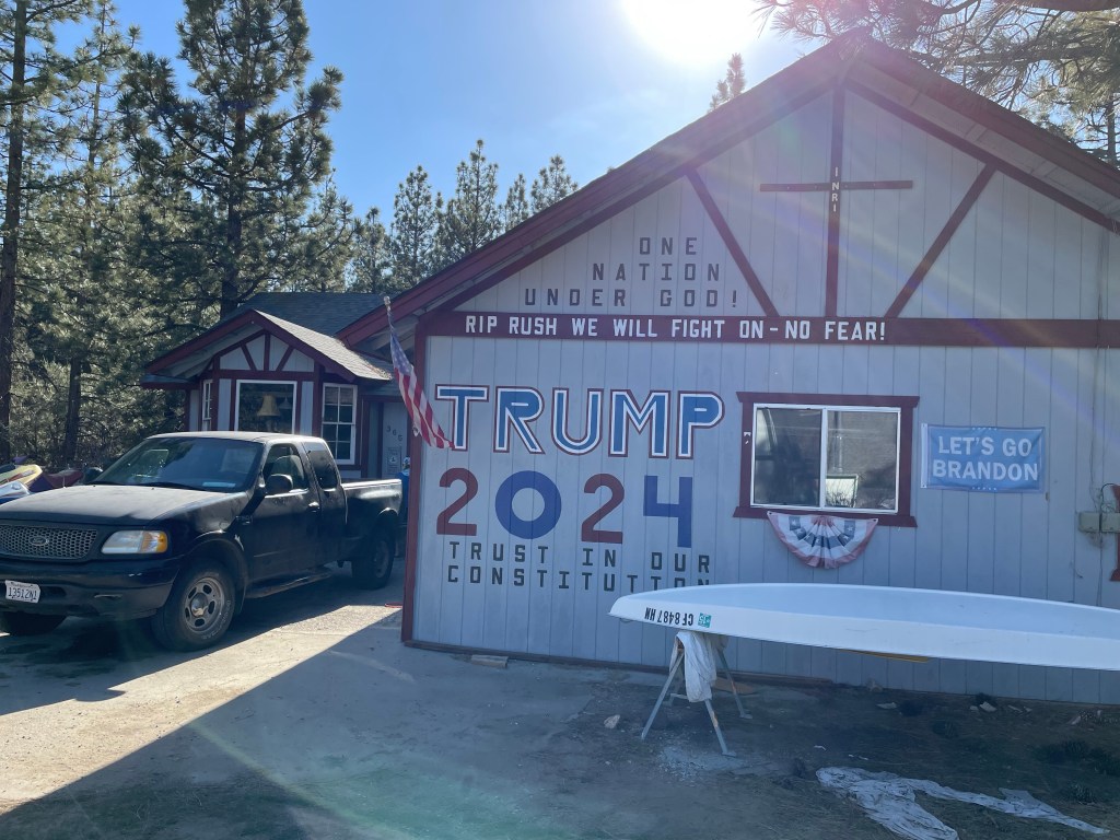
We got to Kenny’s place and his garage door was painted with “Trump 2024” in huge letters. We were not sure what we were in for. However, Kenny stated that talking politics was not allowed in the house. In spite of our different political views, we found Kenny to be a most gracious host and we all had a great time during our stay.
After Kenny showed us around and explained how things worked it was time for dinner and resupply. Eight of us went to the local diner/bar and had a great meal. During dinner, a hiker with trail name “Butterfly” was trying to find names for hikers who had not yet acquired names. Ellen took charge of collecting cash for the bill and at that moment was given the name “TC” for “Take Charge”. Jack was given the name “Commander”. Then Kenny took four of us to the grocery store to do our resupply.
We also did our laundry as soon as we got to Kenny’s. Once back from dinner and resupply we were both exhausted and could not think about putting our food together. It will have to wait till morning. We had had a long day, hiked 17.9 miles, it was already 9 pm. Way past our bedtime!
12 hikers stayed at Kenny’s last night! Plans are for Kenny to drop most of us back at the trailhead tomorrow morning.
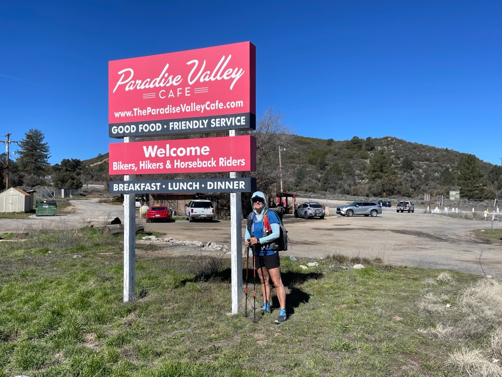
Start: Paradise Valley cafe – 151.9 End: – 159.7 Miles: 7.8 Ascent: 1878 ft| Descent: 450 ft
Start time: 1:40 pm End time: 6:28 pm Current elevation: 6319 ft
We woke up at Ellen’s brother’s house (Pete and Debbie) and got some really yummy breakfast burritos. We left the house around 9 am and they drove us back to Paradise Valley Cafe just before 11 am. It was really weird being back at PVC.
All in and Ryan arrived about an hour later and we all had lunch together. Then it was time to get back to the trail. All In’s sister and brother in law gave us a ride back to the trail one mile away.
It felt great and strangely normal to be back on trail after roughly two days off. The trail wound itself through low desert with big boulders. It was hot but easy going.
Water was starting to get scarce so after 6 miles or so we took the 0.4 mile trail to Tunnel Springs. We left our backpacks at the main trail and just carried our water bladders, bottles, and filters. We filled up and it was time to find a camping spot.
After a short time we found a great site with flat ground and a couple rocks to sit on. We had dinner and discussed the next days plan regarding snow and water. It should be an interesting day.
Day 33
Start: – 159.7 End: Past Apache peak – 170.9 Miles: 11.2 Ascent: 2924 ft| Descent: 2454 ft
Start time: 7:07 am End time: 5:28 pm Current elevation: 6903 ft
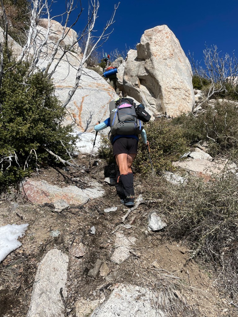
We got an early start with the intention of doing 15.7 miles. We’ll that didn’t happen! We ended up hiking only 11.2 miles. mostly because of the many trees blown down over the trail. San Jacinto Wilderness is a tough place to hike. With or without the snow.
The first half of the day was snow free but a very rocky and tough trail. We had to do some off-trail scrambling and it was pretty steep.We had a late lunch, around 1:30 pm. Then it was time to tackle Spitler peak and Apache peak.
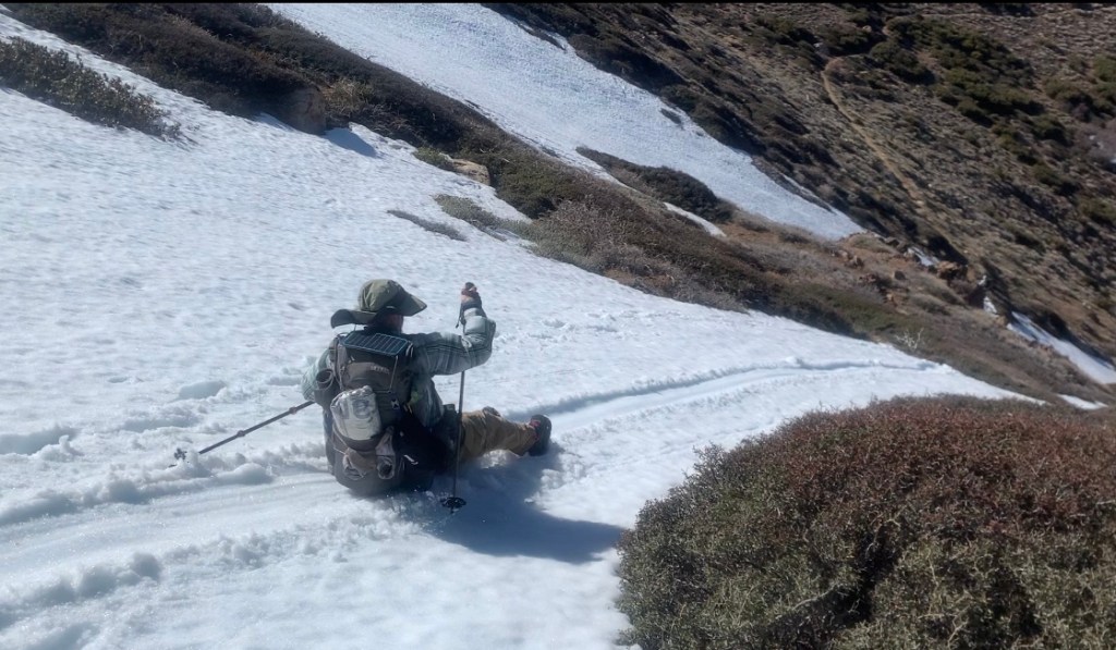
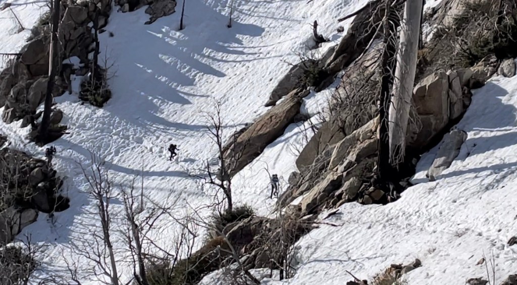
The north side of Apache Peak was holding snow and it became apparent that the slope was too steep to traverse in the soft snow. We were concerned that the snow would slide out under our feet.
So instead, we turned around and went over the peak saddle and resumed the trail on the other side. We even did some glissading in our butts!
Once back on the trail we had another 0.6 miles before we would encounter any place suitable for pitching a tent. It was late so we all decided to camp. It was a very windy but we were some sheltered in the saddle and small trees.
It was an adventurous day on the PCT in the San Jacinto mountains.
Day 34
Start: Saddle past Apache peak – 170.9 End: in the snow – 180.9 Miles: 10.0 Ascent: 3246 ft| Descent: 1215 ft
Start time: 7:14 am End time: 5:48 pm Current election: 9193 ft
Hiking on snow is very slow work.
We all got up early as we knew it would be another day of blowdowns and snow travel. The wind continued to blow making it feel a lot colder.
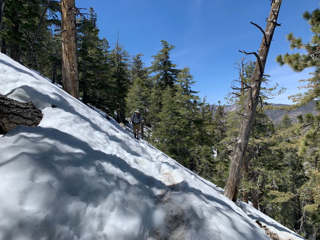
Right away, the snow reappeared and another day of slow travel. We had to go around many tree blowdowns and would often loose the trail and have to bushwhack to find it again.
Some of the trail also had some steep slope exposure and this necessitated slow careful travel. We all took our time and made sure we were safe and make wise decisions.
After about 4 hours we only had gone 4 miles. We found a large rock that had snow melt water trickling over it, and since we were all nearly out of water, we stopped there for lunch and to collect water.
We were both getting frustrated with the trail today. We were tired of bushwhacking around the tree blowdowns, the steep off-trail scrambling, and the slow traverses across the steep snowy slopes.
In the afternoon, the trail was mostly in the pine forest and well away from the slopes. It was getting late and we finally found a relative flat spot under a tree out of the wind for our campsite. We had only gone 10 miles and it took us ten and a half hours.
Day 35 Start: in the snow – 180.9 End: strawberry junction – 183.5 Miles: 2.6 Ascent: 191 ft| Descent: 1009 ft
Start time: 7:22 am End time: 5:36 pm Current elevation: 7432 ft Non-PCT Miles: 9.6 miles Black Mountain rd start elevation: 5446 ft
While reviewing the maps last night, we decided that we’d had enough of hiking on steep snow exposed trail. The Fuller Ridge trail section ahead of us was rumored to be hazardous and so we decided to hike an alternate route (as did many other hikers). We would later learn than Fuller Ridge was not that bad, but we were comfortable with our decision.
We ate breakfast in our tent (out of the wind), packed up our gear, and waited until the last minute to put on our wet socks and shoes. As long as we were moving our feet would stay warm.
After about an half hour we were standing in a nice meadow looking at where the trail was going. Something wasn’t right, the trail was supposed to go down but this was going up. We checked our trail app and noticed that we had missed a trail junction. We turned around and located the correct trail (really just a set of footprints in the snow) and then continued on.
It was 2.3 miles to the next trail junction that would take us down to the valley. This section had stunning views but also steep snow slopes and so we carefully made our way.
At Strawberry camp we made the left turn and took the Deer Springs trail down. This was a 4.1 mile hike downhill to the road. The snow disappeared rather quickly and in no time we were down to hwy 243.
We found a creek and filled our water bottles. Then we needed to find a ride to Black Mountain road, a dirt road which we could hike back up the mountain. It didn’t take long before Frank pulled over and offered us a ride. He calls himself a trail “archangel” because he lives in Pine Cove which sits at a higher elevation than Idyllwild and many other trail angels.
Black Mountain road is a dirt road that goes up to the northern end of Fuller Ridge. It became snow covered as we reached the 6500 ft level.
We found a relatively flat area without snow under a big pine tree and set up camp there for the night. It was a very peaceful evening as there was no wind and the temperature was pleasant.
Day 36 Start: Black mountain rd & Fuller ridge – 190.7 End: I-10 underpass – 209.5 Miles: 18.8 + 1.7 = 20.5 Ascent: 478 ft| Descent: 7533 ft
Start time: 7:22 am End time: 6:55 pm
Black Mountain Rd to Fuller Ridge junction: 1.7 miles with 227 ft elevation gain.
After a somewhat great quiet night sleep we got going at our usual time. Ellen is pretty picky about where to pitch the tent as she wants is perfectly level. However, when she chose last night’s site it was slightly angled and Jeff kept rolling into her.
After 1.7 miles we were back on the actual PCT. Now it was time for a very long 19 miles 6500 ft elevation decent to Interstate Highway 10. The snow had vanished a mile or so down the trail.
As we went down more and more flowers were blooming. We even saw several prickly pear cactus blooming. After what seemed forever we finally made it to the last 4 miles of flat road walk. However, first we got some water from the water spigot.
We finally made it to the underpass after almost 12 hours in trail. We contacted a local trail angel named Nitsy who picked us up and brought us to the Hampton Inn in Banning. It was a very long day but we did our first 20 mile day!
“Zero” day! We had some family matters to take care of and we needed to drive back to Costa Mesa. All In and Ryan were also at the hotel. We all had breakfast together and each had multiple plates.
We rented a car and offered All In, Ryan and another hiker, Charlie, a ride back to the trailhead. However, it was now lunch time and we all were hungry again. Time for In-n-Out burgers. We dropped off the guys around 2 pm back at the I-10 underpass. We just became trail angels! Hopefully we’ll see them soon again.
We are Trail angels!
We then proceeded to drive back to Costa Mesa. We are hoping to be back on trail on Tuesday.
Start: Willow Springs Road- Tehachapi – 558.4 End: top of ridge – 572.9 Miles: 14.5 Ascent: 3596 ft| Descent: 1589 ft
Start time: 9:40 am End time: 5:20 pm
Long day of climbing (again). We had a nice breakfast at the hotel. Ellen went to the gas station and got 4 gallons of water that we used to cache ahead at Highway 58, eight miles into our intended path. Our trail angel “Split” (Mike) first drove us to Highway 58 to cache our water and then drove us further south to where we left off yesterday at Tehachapi-Willow Springs road.
We had 8 miles to go to get to the highway. The first half of course was up and through the wind farm. There was not breeze and with a relative late start it was warm. We also were carrying 6 days of food.
Once over the top it was a quick descent to the road and then a 1.5 mile road walk to our water cache. It took it about 3 1/2 hours to do the 8 miles. Not bad. We grabbed our water and sat down for an extended lunch break. The major discussion was if we had enough water for the next couple days. The next water source was 16.5 miles away.
As we left the highway, we noticed small painted rocks with encouraging message.
It was finally time to do the steep climb. The first 2 miles was along the freeways with a gradual climb. Then the fun began. The next 2 miles we’re straight up and in the hot sun. We were glad it was early April. We could not imagine doing this climb in late May or June. Hot hot hot.
Ryan pretty much raced up the mountain. The rest of us slowly made our way up. We got to our predetermined camping spot at 12.5 miles for the day. But Ryan was gone. We took a break and decided to do 2 more miles. And yes, more climbing. About an hour later we found Ryan at the next campsite. We were both tired and decided to stay while Ryan and All In did 2 more miles. We’ll see them in the morning as they are late sleepers.
As we were climbing today we got a great view of the valley below and the mountains we climbed last week.
Day 26
Start: top of ridge – 572.9 End: the gate – 591.2 Miles: 18.3 Ascent: 2441 ft| Descent: 3374 ft
Start time: 7:22 am End time: 5:23 pm
Another long day with a new personal mileage record. We got our usual start around 7:30 am. A couple of hours later we caught up with All In and Ryan. We had one more big climb to do today.
We finally got to Golden Oak Spring around noon. We did 10 miles in four and a half hours. We all lingered and took a long lunch.
Our next water source was another 16 miles away. We all decided to carry 5 liters of water and go another 8 miles to a gate that looked like it might some flat areas for camping.
Around 5:30 pm we made it to the gate. We doing a somewhat level site. All In and Ryan decided against going further and also found a space for their tents nearby.
We were all in agreement concerning this section so far … not great. The landscape is pretty boring, we have long water carries, and there are windmills everywhere.
Day 27
Start: the gate – 591.2 End: under the pines – 607.5 Miles: 16.3 Ascent: 3696 ft| Descent: 2333 ft
Start time: 7:22 am End time: 6:22 pm
Today was another long day, which seems to be happening more … but we are in a groove. Our first goal was to get to Robin Bird Spring, a mere 12 miles from camp. It should only have taken us till about 1 pm based on what we did the day before. However, it was very slow going.
Immediately the blow downs started. With all the wind and snow this past winter, there were a lot of trees down across the trail. Ellen started counting them and after 16.3 miles we encountered 127 trees down. Some were small which just required an easy step over. Others were massive trees which required some fancy maneuvering to get by.
We finally made it to Tobin Bird Spring around 2:30 pm. We wanted to go at least 4 more miles to make 16 miles in for the day. We took a little rest and then resumed at 3 pm.
Immediately the fun began with the snow. We were now on the north side of the mountain and there was a lot of snow. The snow was soft so even with stepping other people’s foot prints, we often still post-holed. Fortunately, this only lasted a short distance.
Before we knew it, we entered a pine forest with tall Ponderosa pines. We found a flat, dry spot nearby a fast flowing creek. All In and Ryan found their tent sites across the creek. We set up camp on the soft ground that was covered in pine needles.
We set up camp, made dinner and went to bed. It had been a long day and we were tired. But, wouldn’t have it any other way.
Day 28
Start: under the pines – 607.5 End: in the. Joshua trees – 625.5 Miles: 18.0 Ascent: 2372 ft| Descent: 3274 ft
Start time: 7:29 am End time: 5:28 pm
Another great and challenging day. We started off on the nice pine forest and ended up on a windy ridge tenting between Joshua trees.
Other (southbound) hikers had described more snow in trail ahead and so we put on our dry socks and the snow baskets on the trekking poles. The first half mile consisted of a few creek crossings and some intermittent snow over the trail, but nothing like we had been told. Before we knew it we were out of the forest and back to the desert.
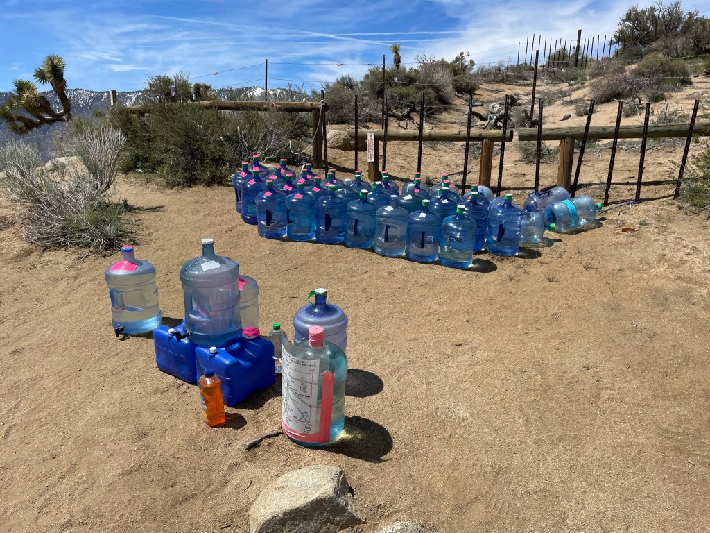
It was a long grind to make it to our next water source. We made the 12 mile hike to the water cache on Kelso Rd. Wow what a cache! There were at least twenty 5-gallon jugs of water! Thank you trail angels! We had an extended lunch which included planning the next trail section and deciding on how much water the carry … ugh.
Kelso road cache
Our next reliable water source was 14.5 miles away at Bird Pass Rd. The same trail angel had left water plus power banks to charge electronics. Awesome! We decided to do a max carry of 5 liters. Yay, another heavy backpack.
Bird pass road cache
To pass the time on trail, we finally gave in to listening to audio on our phones. Jeff was listening to an audio book while Ellen listened to a couple pod casts. The wind really had picked up and some of the gusts almost blew us off the trail.
The time and miles clicked away and before we knew it we saw All In and Ryan at a campsite in a grove of Joshua trees, somewhat out of the wind.
We did 18 miles and now only have 27.5 until Walker pass and two days to do it in.
Day 29
Start: in the. Joshua trees – 625.5 End: McIvers cabin – 645.0 Miles: 19.5 Ascent: 3763 ft| Descent: 2626 ft
Start time: 7:39 am End time: 5:54 pm
19.5 trail miles today! Wow. But let’s start at the beginning.
What we thought was a wind protected campsite turned out to be anything but. The wind came up the valley and right into Ellen’s side of the tent. Then the wind changed directions and swirled in from all sides. The tent was shaking hard and without the benefit of large rocks to keep the tent stakes in the ground, the main stakes were getting ripped out of the ground. The tent was on the verge of collapsing. Jeff got out and used some rope he had brought to tie the tent off to a dead Joshua tree and a thorny bush. We finally got some sleep despite the flapping of the tent in the wind.
In the morning we got up at our usual time and packed up. Ryan had left at 7 and the three of us left a little after 7:30 am.
The wind was relentless for most of the morning. We did a little climb and then back down to a valley. We had about 6.5 miles to the next water source.
After about 2 1/2 hours we found Ryan at Yellow Jacket Spring. It was a confusing intersection and the spring was 3/4 mile off-trail, so he he had brought up a few liters of water to share with us. We had a snack and decided to continue to a seasonal stream a 6 miles away. This way we only had to carry 2 liters. Once we got to the stream we decided to continue on to a cabin that was by a stream.
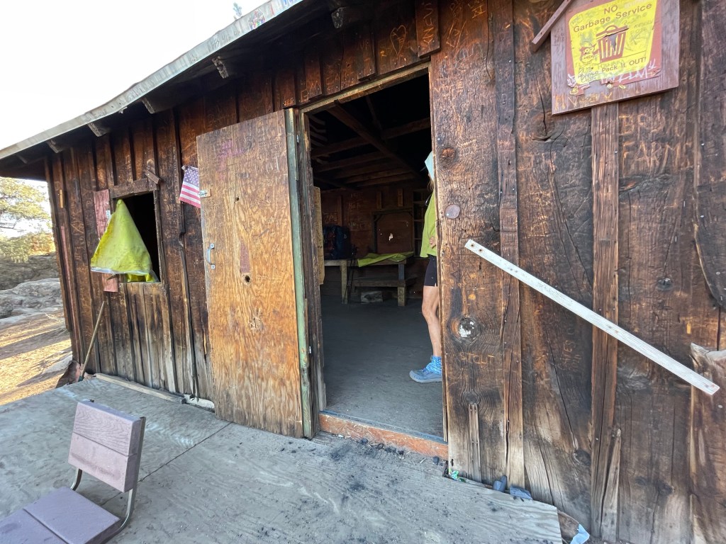
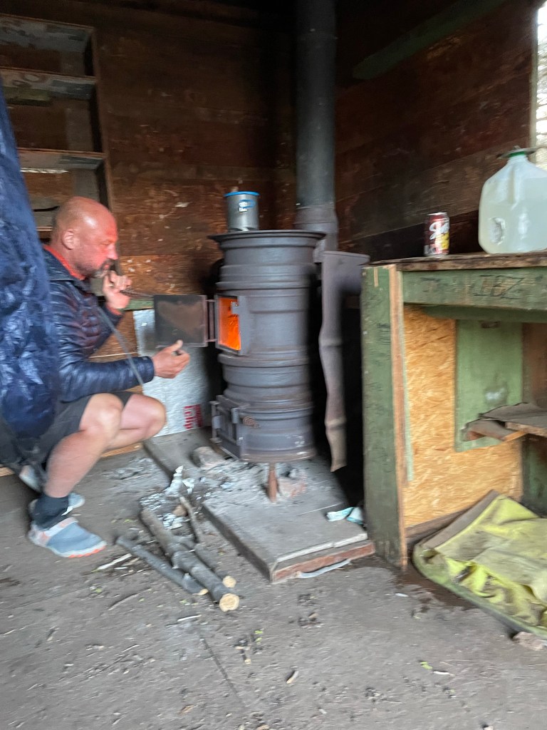
McIvers cabin is an old miners cabin that was moved to its current location years ago and now used by off road enthusiasts and hikers. It even had a wood stove! We found a flat spot to pitch our tent while All In and Ryan decided to stay inside the cabin. They made a fire in the stove and it was soon very warm inside. A nice reprieve from the wind the cold. We all had dinner inside the cabin. Total miles hiked was 19.5 on trail plus 0.2 side trail to the cabin. Personal best for all of us.
Town day! Ryan woke us up at 5:30 am since we all wanted to get to town. The wood burning stove in the cabin was out so it was cold. We woke up to a frozen tent. We quickly packed everything up and went to the “warmer” cabin to have breakfast.
We left the cabin cleaner than we found it and headed out. It was cold. We we’re all bundled up until the sun broke out. We all practically ran down the trail.
We got to the north side of a hill side and found a few patches of snow to deal with, but now big deal. The trail was easy and we made the 7.5 mile trek to the Walker pass campground in two hours.
It was then time to find a ride into Ridgecrest. The road wasn’t too busy, and so trying to find a hitch for four people was not working. So we split up and All In and Ryan walked down the road a bit. Within a few minutes our trail angel Charlotte stopped her car. What a sweet lady! She drove us to Ridgecrest and stopped at three different rental car places. We needed to rent a car to get us back to SoCal but for some reason all the rental car places had no cars.
We let our trail angel so we could decide how to get south. As we are walking in the parking lot, All In and Ryan showed up with their trail angel. We were all hungry as we had been dreaming of town food all day. We ended up getting pizza.
As we were discussing on how we should get sloth, Ryan suggested to rent a U-haul truck. We’ll we did. It was easy and a lot cheaper than a car. We made the four hour drive to Ellen’s dads.
We made plans with our “tramily” to meet back up in Paradise Valley Cafe in a couple days to tackle the Southern California mountains.
Start: Hiker Town – 517.6 End: Hiker Town – 517.6 Miles: 0.0
We woke up with the intention of getting back on trail after we receive our FedEx box. However, we didn’t get our box until 12:30 pm and by that time everyone else already had decided to take a zero. It didn’t take much convincing for us to also stay.
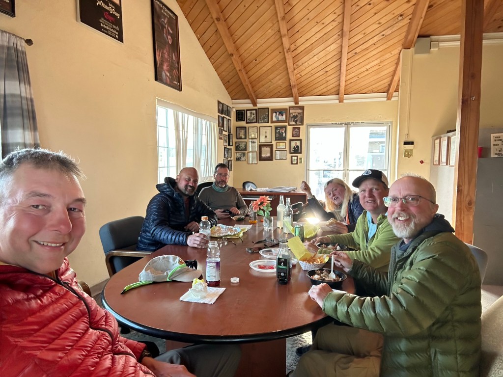
We spent the rest of the day just hanging out and getting to know each other . There were 6 of us: Jeff, Ellen, Dave, other Dave (All In), Mike (Old Goat), and Ryan
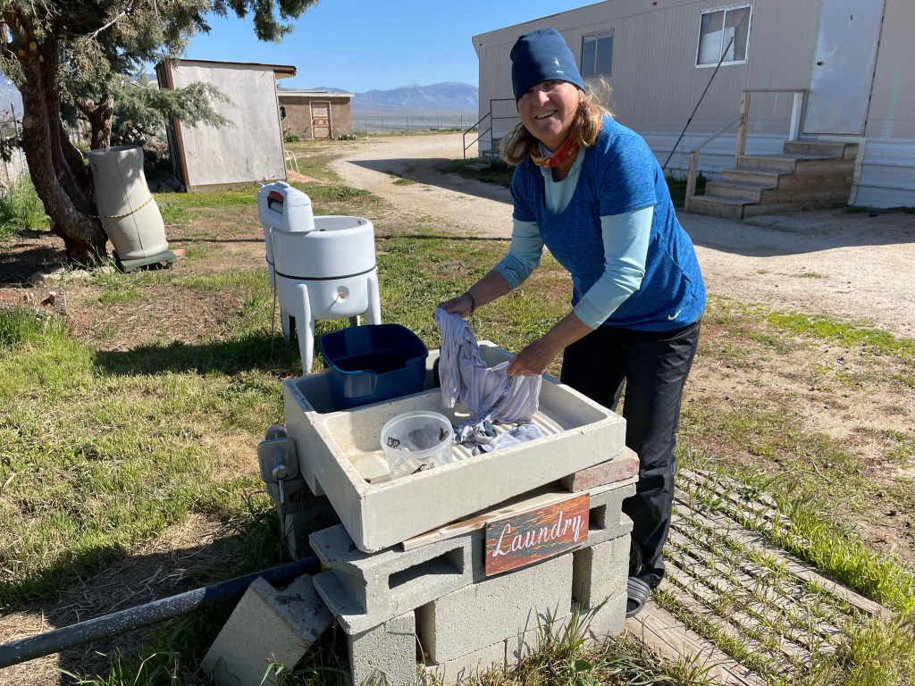
Ellen did some laundry the old fashion way using a scrub board and buckets of water. It’s amazing how much dirt came out of her shirt and socks.
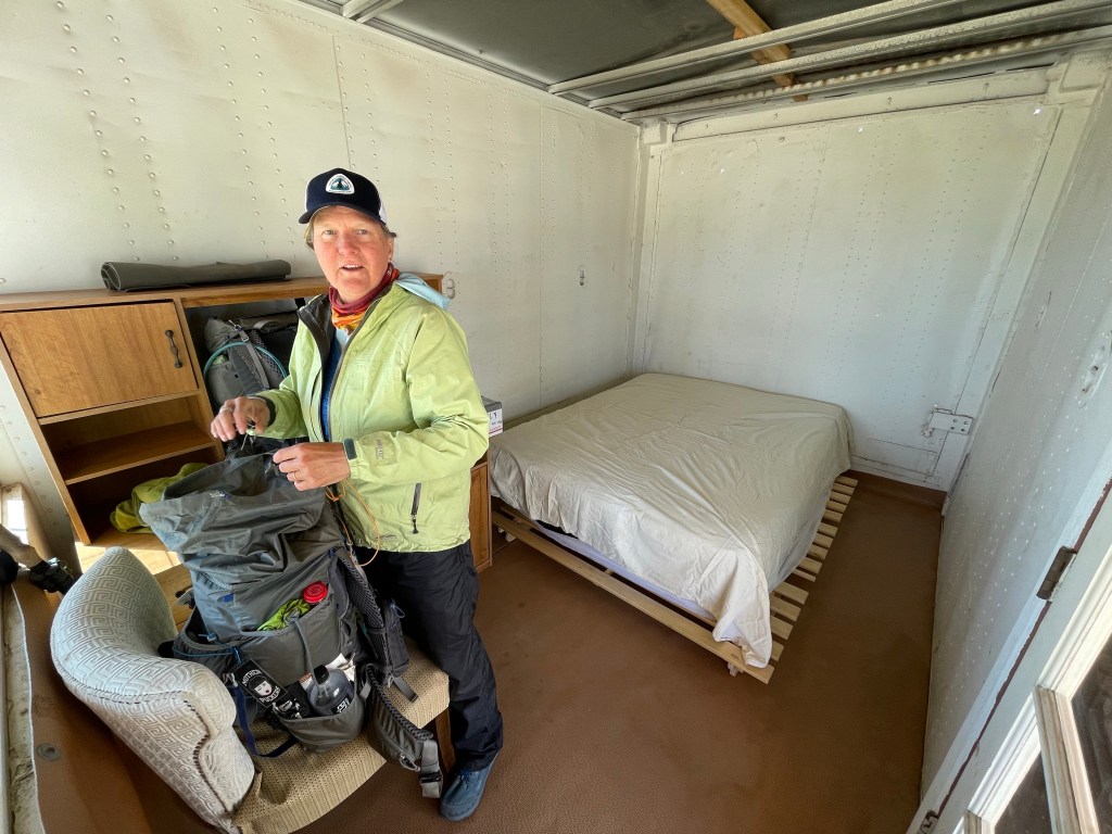
Later in the afternoon Jeff got bored and Ellen talked him into fixing the door knob on our “room”. He then fixed another door knob. The group wanted to give home the trail name “Door knob” but he refused to accept.
We all went back to the Neenach Gas Station & Market for dinner. Plans were made for most of us to hike to Cottonwood Springs the next day, 17.6 miles away.
It was a nice day to relaxing and making new friends
Day 22 Start: Hiker Town – 517.6 End: Cottonwood creek – 535.0 Miles: 17.4 Ascent: 708 ft| Descent: 950 ft
Start time: 6:33 am End time: 2:43 pm
Our longest day yet with the much anticipated aqueduct walk. We had our earliest start of 6:33 am. There are advantages to starting that early as we both saw the sunrise and moon set at the same time. Very pretty.
The hike was not that exciting. 99% of the trail is basically a road walk next to either the California aqueduct or the Los Angeles aqueduct. We both had seen lots of video and pictures of people hiking the aqueduct and it was amazing to actually be there now. But that feeling wore off quickly after a few miles of the road walk. Mike reported that he fell asleep while hiking.
LA aqueduct
We did really well in the morning as we did over 11 miles by noon. We took a lunch break under what Jeff deemed was the perfect Joshua tree.
After lunch the afternoon seemed to drag on. The wind had stopped blowing and the sun was starting to heat things up. We finally made it to Cottonwood creek at 2:30 pm. The creek was flowing fast and the cold water felt really good on our sore feet. Our feet took a beating today.
Jeff wanted to go another 2.6 miles to make it a 20 mile day but Ellen vetoed that idea. The thought of carrying a water uphill to a dry camp with feet that were aching did not appeal to her.
We decided to stay and eventually Old Goat, All In, and Ryan showed up. We all soaked our feet and had dinner together by the creek along with 5% and Jojolynn, 2 south-bounders that were also camped there.
All In, Jeff, Jojolynn, 5%, Old Goat, Ryan
Day 23
Start: Cottonwood Creek – 535.0 End: Top of climb – 549.6 Miles: 14.6 Ascent: 4123 ft| Descent: 1016 ft
Start time: 7:33 am End time: 4:54 pm
Another long day. Not as much for distance but for time on the trail. The entire day we spent climbing. The first part of the day was spent walking through the wind farm. It was pretty cool to be up close to those big wind mills.
Then the trail did some crazy stuff. We thought we would be going directly into the mountains. However, the trail wound around the dry, motor cycle tracked hills for miles. We thought we had seen the last of the windmills, but the trail took us right back towards them. We could have saved about 6 miles if the trail took a direct route. We guess that is just part of the adventure.
We had lunch at a very tiny creek where Jeff soaked his feet.
We were ready to “camel-up” (carry as much water as possible) for the hike to the top and beyond at the last flowing creek, until a south bound hiker told us that there was a water cache at the top with 10 gallons of water. We dumped 2 liters of our water and set off on this long 3.9 mile climb. When we got to the water cache we found that there was only about one gallon of water. We only took 2 liters and messaged our friends who were behind us to camel-up at the creek.
We finally made it to camp close to 5 pm. The rest of our “tramily” (trail family) showed up a little later. We all had dinner together at our place – by our tent. We made tentative plans to stay at the same hotel in town.
Ryan, All In, Old Goat, Ellen & Jeff
Day 24
Start: Top of climb – 549.6 End: willow Springs Road- Tehachapi – 558.4 Miles: 8.8 Ascent: 500 ft| Descent: 2701 ft
Start time: 7:23 am End time: 11:02am
We made a last minute decision last night to only go 8.8 miles to the Willow Springs road and then get a ride into Tehachapi. “All In” needed to mail a package before the post office closed. We decided to go into town with All In and Ryan. This way we would have most do the day in town and then could leave the next day in the morning. Avoiding taking another zero.
The hike down went really fast as all of us had town food on our minds. We did the 8.8 miles in just under 3.5 hours including many short stops.
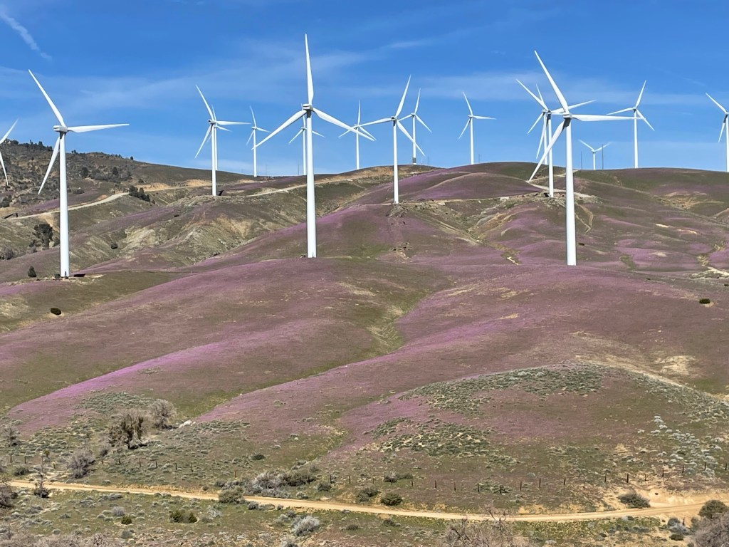
The trail also made its way through more wind farms. The hills beneath the wind mills were purple from the millions of tiny purple flowers.
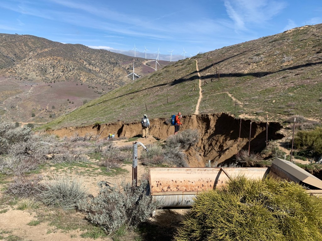
We had been warned by SOBOs that the trail was totally washed out at mile 555.5. Sure enough, the trail was gone and what was left was a ravine. Previous hikers had made a path around the ravine but we decided just to got down and back up the ravine. It really wasn’t as bad as everyone made it seem. Plus it was something different.
Mile 555.5 ravine
We got to the road around 11 am and started looking for a ride into town. A pickup pulled up across the road and waved us over. Bill and Virginia were putting up posters advertising their restaurant, Kelcy’s Restaurant, with free beverages for PCT hikers. They were very generous and drove us to the post office and patiently waited as “All In” was mailing his package. We decided to eat at Kelcy’s since Bill and Virginia were so nice.
Ryan and Jeff analyzing the windmills
After a monster burger and fries we headed over to our hotel and dropped our backpacks. Check in wasn’t until 3 pm and it was only 1:45 pm. We decided to walk over to the Walmart and do our resupply. While at Walmart, Mike P asked if we were hikers and explained he was a trail angel. He asked if we needed a ride tomorrow and of course we said yes.
Once we checked in it was time to get cleaned up, put our food forget and the big time: laundry! The hotel had a laundromat and Ellen got everyone’s laundry done. Only $5! Not bad.
Our little tramily went to dinner at TKs pizza and beer. Good food and very busy. We spent dinner looking at the various PCT Facebook pages and the maps trying to determine the water situation for the end t couple of days. Conclusion: we need to carry lots of water for 2 days as there is very little water for 24 miles. Oh well, training with heavy packs for the Sierras.
And yes, we are still waiting for our trail names.
After sleeping in till 8 am we got up and after breakfast decided to do laundry. We aired out our sleeping bags, cleaned the tent and looked over all of our get. Ellen was very excited about a new pair of trail runners.
We ran around town looking for some specific foods that we wanted plus some other supplies. The rest of the time was spent visiting with family.
We did got to our favorite taco place called Taco Mesa. We each got a big burrito with chips. Yummy
Day 15
Start: – 151.9 End: – 151.9 Miles: 0.0
Zero day #2 in Costa Mesa
Went to REI to get new socks. Finished putting our trail meals together and packing our backpacks.
Ellen’s brother Pete and his wife Debbie came over and we all went to Ellen’s dads favorite place- Avila’s El Ranchito for dinner.
It was early to bed since we had a long drive in the morning to get back on trail.
Time to get back on trail. We made the decision to skip ahead to Vasquez Rocks (mile 453.6) in order to miss the snow on Mt. San Jacinto and all the snow in the San Bernardino and San Gabriel mountains.
Jeff’s brother Jon was gracious again to give us a ride to Vasquez Rocks. After almost a 2 hour drive we finally got started just before 9 am. First order was to do the road walk through Aqua Dulce. Aqua Dulce is only one of two towns that the PCT actually goes through.
As we were walking through town several cars honked at us and gave us thumbs up. An owner of a restaurant even offered to buy us breakfast. We had miles to hike and so had to decline. People as amazing!
After about an hour we made it into the hills and left the town behind. Our packs were full and our legs were not used to hiking after sitting around for two days. It was a long climb but the view got more beautiful the higher we got. We got a glimpse of the snow covered San Gabriel mountains.
Going up from Aqua Dulce
We made it to the top and then it was a long decent down to Bouquet Canyon Road. The top of this side of the mountain had a totally different feel. Gone was the desert looking environment. Instead it was forested with lush ground cover. There were still patches of snow and the ground was pretty water saturated. We found a good flowing creek and each got 2 L of water with the hopes that more water would be available down the trail. The water seemed to disappear as we got down in the valley but eventually found a small stream.
We really wanted to keep going , but the thought of carrying 4-5 liters of water up another hill for 3 miles did not seem fun. Plus, our legs and feet were tired. So we opted to make camp by the stream. We only did 11.8 miles, but we really wanted to do more.
This entire section requires careful planning for water and making camp.
Day 17 Start: Bouquet Canyon. Rd – 465.4 End: Top of fire break – 482.5 Miles: 17.1 Ascent: 3505 ft| Descent: 3086 ft
Start time: 7:23 am End time: 5:30 pm
Our longest day yet! We woke up to a wet tent in and out because we were again camped in a low area by a creek. The trail was awesome however – no big rocks just small gravel and dirt. First order of business was the climb out of the canyon. Water seemed to be everywhere again.
After a little bit we met a recent army retiree named Dave and we kept leapfrogging with him. We also saw a lot of south bounders (SOBO) hikers that had flipped up to Tehachapi from the south to avoid the snow.
There was one great water source, a waterfall. To help prevent the trail from eroding a Boy Scout troop had placed a pipe under the trail to help move water down the hill. It was very cold water but Jeff could not help but put his head under it.
At one point Jeff and Dave started hiking together. While they were having great conversation they missed the trail at a road crossing. They ended up hiking down a dirt road for half a mile before realizing their mistake. As luck would have it, a Jeep was coming up the trail and offered to give to them a ride back back up.
At about 1:30 pm we made it down to the road to Green Valley. A trail angel had left some snacks and beverages in a tub under a tree.. nice! Now it was time for the climb back up. We weren’t sure where the next campsite was since most of the trail was carved out of the mountain side.
We got to the top of a ridge and saw the next valley over. Wow what a view. Antelope Valley was in bloom with the California poppies.
We crossed a couple of dirt roads but decided against camping there. It was the weekend and we had been seeing some people four wheeling and riding dirt bikes.
As it was getting late we found a fire break above the dirt road and that had a perfect flat spot. We actually had a great night with a beautiful view of Lake Elizabeth and the mountains in the distant. It was another day to be on the trail.
Day 18 Start: Top of fire break – 482.5 End: Sawmill campground – 498.2 Miles: 15.7 Ascent: 3468 ft|Descent: 2309 ft
Start time: 7:35 am End time: 5:48 pm
What a day! From desert heat in a burn area to winter condition on the mountain.
As we got started a trail maintenance crew showed up. Many thanks to the volunteers who keep the trail in great shape. We noticed the clear trail as we made our way down to Lake Hughes road and in no time we had made the 3.3 mile hike to the road. Then of course it was time to go up. As we made our way up we met up with several SOBOs including Onward and Trish. We exchanged information about the trail and wished each other happy trails.
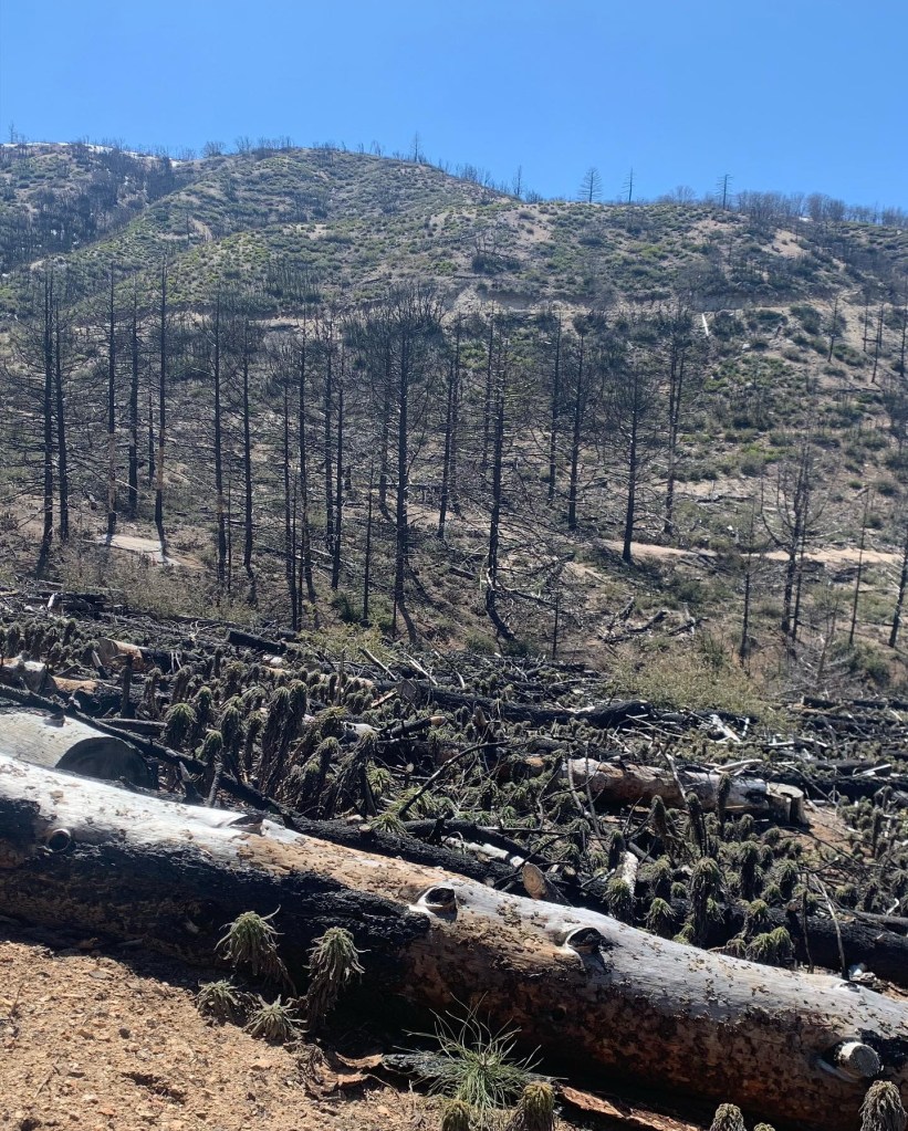
After about 4 miles we got into a major burn area. It was pretty ugly. One of the first plants to grow in a burn area is “poodle dog bush”. It is very poisonous and was literally everywhere. We were very careful not to touch it with anything, including our trekking poles.
We finally found a clear spot for much. It was hot and not very fun area. We had heard there was snow nearby but at this moment we could not picture snow.
Hot and yucky!
Finally after what seemed like forever, we started to climb out of the burn area and we found the snow. At first the snow was just occasional patches but the higher we went the more snow was on the trail. With it being late in the day the snow was soft and slippery. We took our time and made it to our last water source for that day and the next. We filled up and continued climbing.
We also met Mike, aka “Old Goat”, and hiked with him for the rest of the day. We were all getting very tired and were glad we made it to Sawmill campground. It had picnic benches and a pit toilet. Such luxury! We set up camp, made dinner and climbed into our tents. The wind had picked up and we knew that there was a high wind advisory for the area (30-40 mph plus higher gusts). It wasn’t until 8 pm when we went to sleep. Way past our bed time.
It was a tough day with our first encounter with significant snow on the trail.
Day 19
Location: The Desert Start: Sawmill campground – 498.2 End: Pine Canyon rd – 510.9 Miles: 12.7 Ascent: 1841 ft | Descent: 2914 ft
Start time: 7:55 am End time: 3:34 pm
Time wise it was a short day, hiking wise it was long. We were awakened by the shaking of our tent several times during the night. The wind was howling and gusting. It also hailed/snowed all night and our tent was frozen. We decided to stay out of the wind by cooking our breakfast in the outhouse. Yes, we know … really, an outhouse?
We along with Mike decided to walk the road that paralleled the trail for about 6 miles. We were worried about the trial conditions and the potential of blow downs due to the high winds.
As soon as we got on the road, we saw the evidence of the high winds. Many big trees had come down during the night. We were glad with our decision.
The road conditions varied from snow covered, frozen drifts, to slick mud. Also the winds continued to blow really hard along with ice pellets. For a few stretches the wind and hail was blowing straight into our faces. It felt like we were getting sandblasted with ice. Not fun. But we wkept going knowing this would end soon.
From looking at the maps we noticed that once we had to get back on trail, there the trail opened up and was wider. This made for much “relaxing” hiking. The wind continued to blow like crazy as we went down the mountain. Several time we saw some great views of the valley below with the snow storm hanging above.
The snow finally started to disappear at about the 4800’ level and we were back on dirt! There again were more trees downed from last nights wind.
We made it to the valley below to our first water source since yesterdays water fall. We stopped early knowing we would only have 6.7 miles to “Hiker Town” the next day. Another great day on trail with new experience.
Day 20
Start: Pine Canyon rd – 510.9 End: Hiker Town – 517.6 Miles: 6.7 Ascent: 881 ft| Descent: 1639 ft
Start time: 8:29 am End time: 11:54 am
Short day today as it was town day! We were only 6.7 miles from Hiker Town. We slept in until 7:10 am! It was still cold and the wind was still strong.
After a little while Dave caught up with us again. We hiked together until we got to town. The sun tried to break thru a few times. As we made our way down we got a great view of the valley below with the Tehachapi mountains beyond.
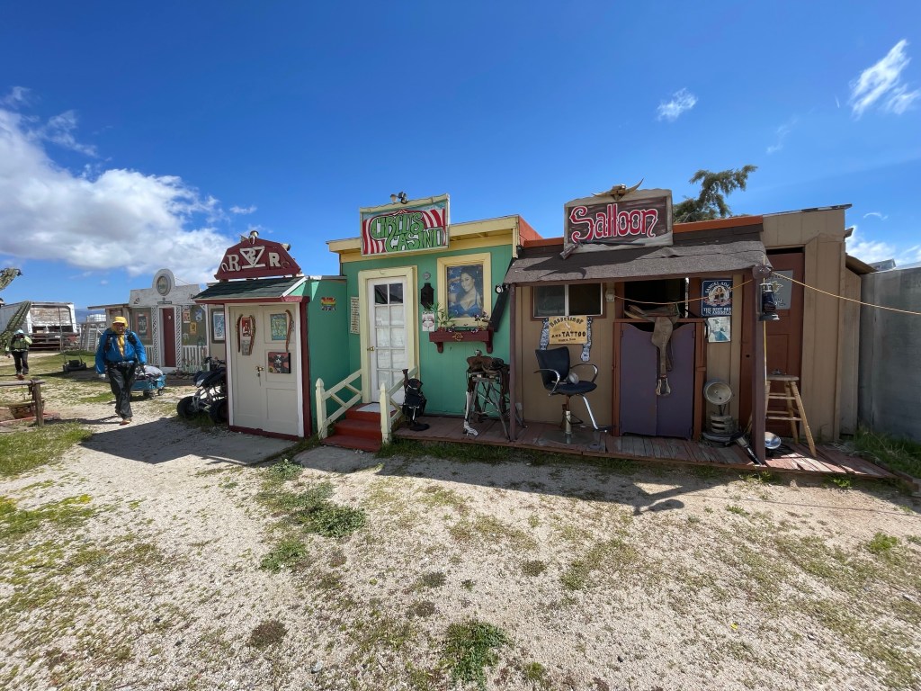
We got to the road fairly quick and then to Hiker Town. Hiker Town is a collection of tiny “buildings” converted into “accommodations” for hikers. It’s an interesting place. We checked in and we were assigned the City Hall building. We also picked up our resupply box we had mailed to ourselves.
Hiker Town
We were all hungry for some town food. We got a ride from a local to the Neenach cafe and market. He drives hikers back and forth between Hiker Town and the market all season. We ordered some food and all worked on our blog and video.
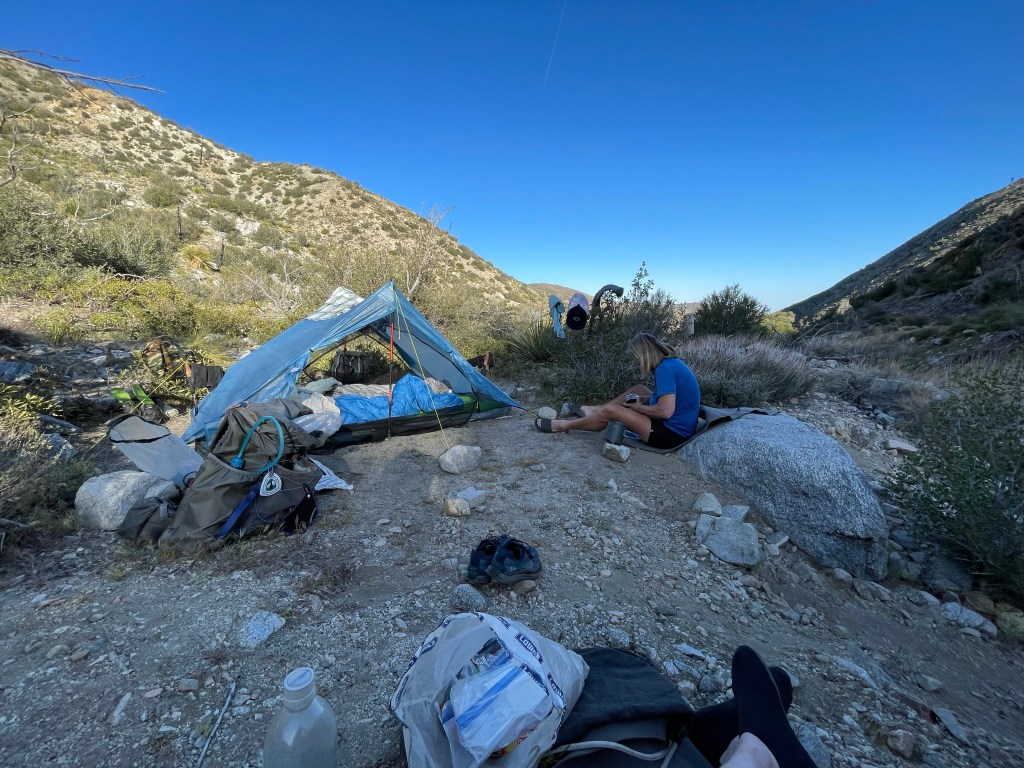
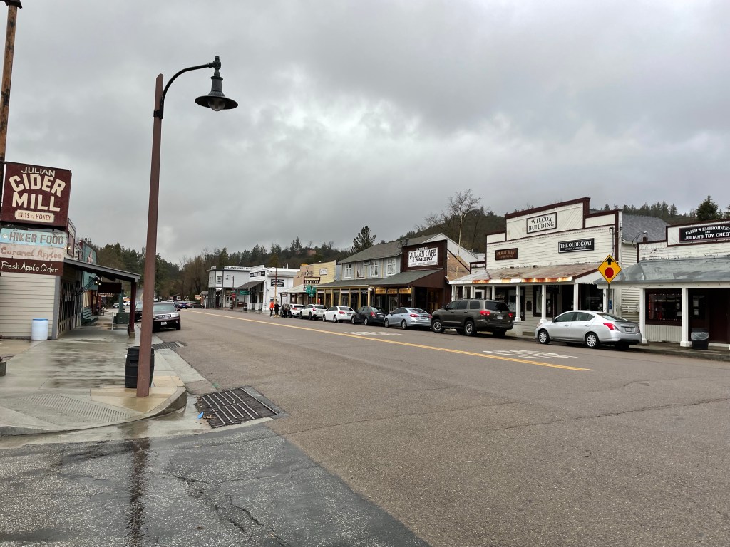
We spent a “zero day” in Julian to wait out the latest California storm and the town was full of other PCT hikers doing the same. We spent the day doing town chores: eating at restaurants, figuring out the next trail section, and watching the weather.
Downtown Julian
Mom’s Pie House gives a free slice and a beverage to PCT hikers so we went there with Ryan and Becky.
Gear Explosion
After looking at the forecast we made the decision to stay another day in Julian! Thank you crazy “atmospheric rivers”!
After waking up, we discovered that the forecasted snow had not arrived and in fact the latest forecast said that it would be only partly cloudy after 10am. So, after some consideration, we decided to get back on trail ASAP! We boiled some water for oatmeal and had a trail breakfast in the room. We did a quick resupply at the grocery store and then packed our stuff. The lodge was gracious and let us cancel our next night reservation.
We were packed up and standing in front of the lodge wondering how we would get to the trail when the hotel manager’s wife, Sage, offered to give us ride. So kind!
We got back to the trailhead at 11:20 am. The wind was howling and it was snowing. For the first half hour, the trail was covered in snow, slush, and mud. As we descended, the trail became a stream in places and our light footwear was soaked. Our feet were working hard though and stayed warm enough.
We did not have to worry about finding water as water was absolutely everywhere. After a couple hours we ate lunch near a stream and filled up on water.
There was no longer any surface water on the other side of the valley but we did find a well at Rodriquez (dirt) Road.
Water!
We knew that we would be dry camping again so we maxed out our water capabilities (4 liters each) and a few miles later we made camp. We were thrilled to have hiked 11.7 miles just in the afternoon.
Day 8
Start ridge – 71.2 End: in canyon below ridge – 84.7 Miles: 13.5 Ascent: 1839 ft| Descent: 1919 ft
Start time: 7:48 am End time: 3:49 pm
A major milestone, Scissors Crossing, lay just three miles ahead. This is a junction of two major roads that resembles a scissor. Usually during the middle of hiking season and when the weather was more typically hot, many hikers hide out under the bridge to wait out the heat. Local trail angels also maintain a water cache under the bridge. Scissors Crossing is also is a key spot for hikers to hitch a ride to and from Julian.
After snacking and filling up on water it was time to begin the next section. The trail climbs up and follows the ridges of the San Felipe Mountains. The trail itself winds in and out of canyons and ravines and covers about 20 miles whereas the straight road below only about 6 miles. The trail was exposed and the wind was howling. Late in the afternoon we found a small tent site deep in a ravine which provided some shelter.
Day 9
Start: in canyon below ridge – 84.7 End: Barrel Spring – 101.1 Miles: 16.4
Start time: 7:32 am End time: 4:26 pm
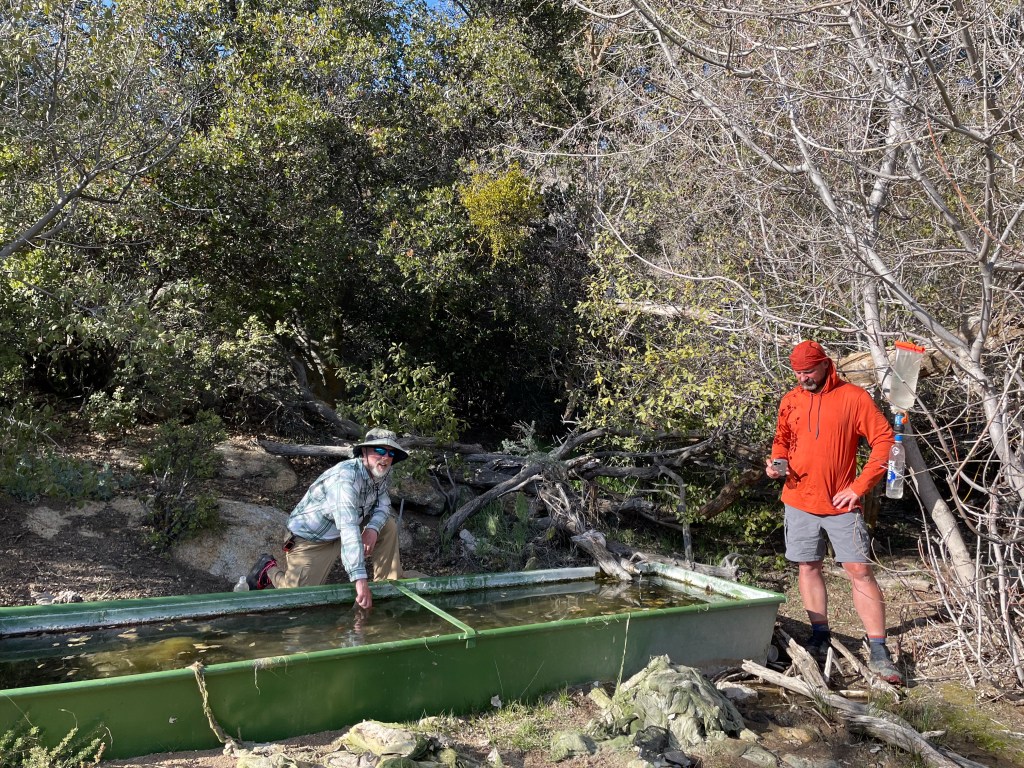
We broke camp and continued along the San Felipe mountains. Six miles ahead there was a water cache not far off trail where trail angels had left 4 pallets of water jugs. Awesome! It also included a wire cage the empty water jugs to be recycled and a container for cash donations.
After filling up on water we continued another 10 miles on a slow descent towards Montezuma Valley and Barrel Spring. But just before arriving there we hit our first major milestone – we had hiked 100 miles!
Upon arriving at Barrel Spring, other hikers mentioned that there was some trail magic by the road. Sure enough, “Crafty” and “Coffee” were handing out pizza and beverages. We both had a few slices of pizza and enjoyed talking to these guys who had previously hiked the PCT. We would save our ramen noodles for another time!
Coffee and Crafty
After dinner we set up camp along with several other hikers near Barrel Spring. Not the best site in the world, but we got pizza!
Day 10
Start: Barrel Spring – 101.1 End: Aqua Caliente – 115.4 Miles: 14.3 Ascent: 1455 ft| Descent: 1829 ft
Start time: 6:58 am End time: 4:31 pm
The morning was cold and foggy as we made our way through cattle pastures and rolling hills.
We passed by Eagle Rock which is a popular day hiking destination.
Eagle Rock
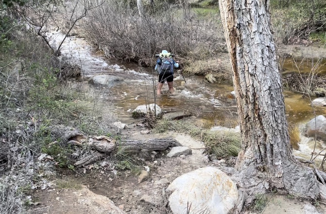
North of Warner springs, the trail climbs back into the mountains along Aqua Caliente Creek and includes five wet foot crossings.
On of the five stream crossings
Day 11
Start: Aqua Caliente – 115.4 End: site near creek – 131.7 Miles: 16.3 Ascent: 3471 ft| Descent: 2094 ft
Start time: 7:00 am End time: 4:26 pm
We woke up at 6am and quickly packed up camp. After putting on our wet socks and shoes it was time to cross the creek once again. The water level was just above our knees and the water was frigid.
Fortunately, the trail climbed steeply and our feet warmed up. After about an hour we found a spot in the sun and had breakfast.
Breakfast along the trail
Today we met a lot of other hikers: Onward, Machine, and Tank. We also ran into Jackie again. There was talk about camping together that night but we all found different sites.
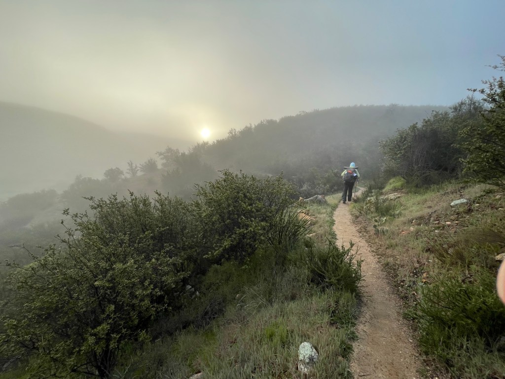
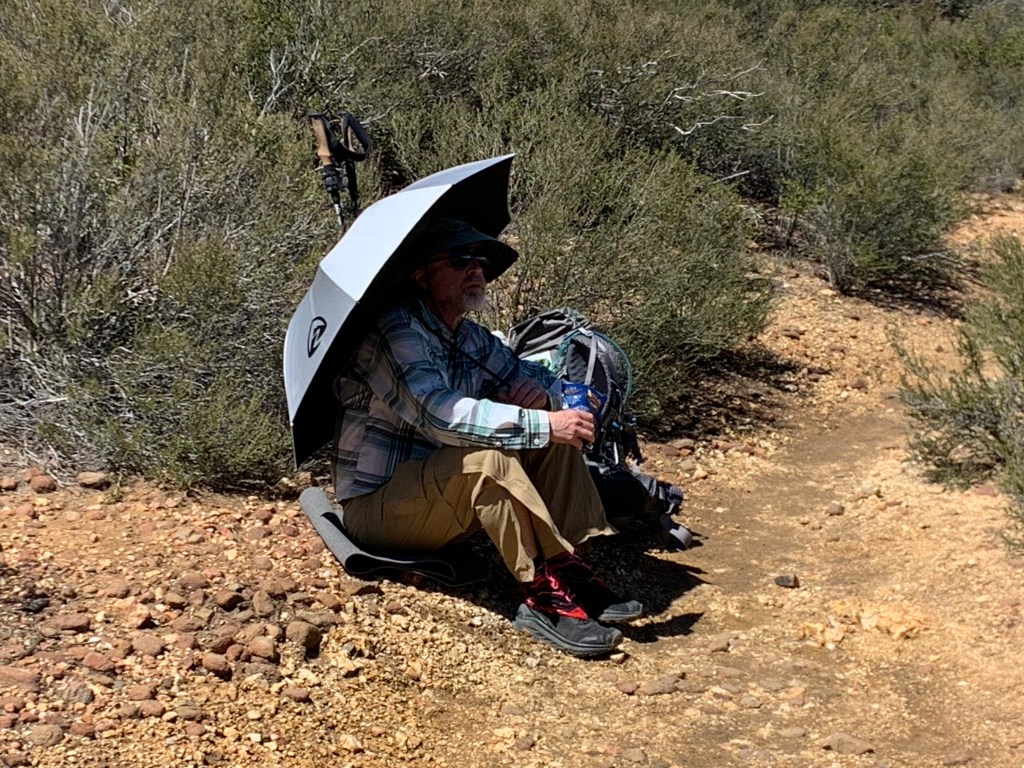
Sun umbrellas do work!
The trail was smooth but often overgrown with scratchy bushes and so the last 4.5 miles went really slow. In several places there was still lingering snow. We were both tired.
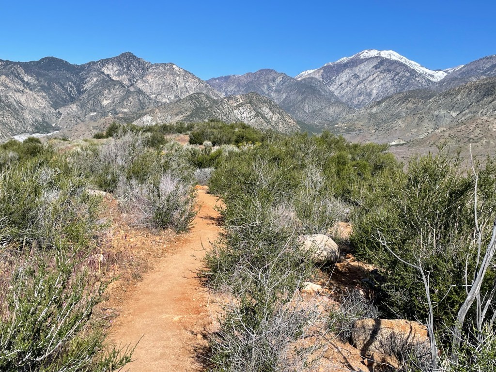
At one point we rounded a corner and got our first glimpse of the snow covered Mt. San Jacinto and the San Bernardino Mountains.
Mt. Jacinto in all of its glory!
We found a tent site in a ravine near a trickle of water and with a great view of Mt. San Jacinto. Once at camp, we soaked our tired feet in the nearby stream. Another great day on trail!
Day 12
Start: site near stream – 131.7 End: Table Mountain – 146.2 Miles: 14.5 Ascent: 2047 ft| Descent: 1968 ft
Start time: 7:32 am End time: 4:26 pm
Our goal today was to hike as close to the Paradise Valley Cafe as possible, but first we had to deal with a cold morning and our frosty tent. The cold air settles into the low areas and boy was it cold! We didn’t have a thermometer, but based on how quickly things froze, we figured it was in the high teens Fahrenheit. However, after just a short while on trail we were in the sun and had stripped off the layers.
The trail was beautiful, smooth crushed rock or hard packed granite sand. The flowers were starting to bloom, including the California poppy.
About a mile before our intended camp location we passed through Mary’s Place. Mary lives just off trail and maintains a water tank for hikers along this arid stretch.
The trail started with a steep climb but then leveled off atop some beautiful cliffs and canyons.
It was pretty easy going because we had real food on our minds. The trail also was busy … and by busy we mean we saw about six hikers all headed for Paradise Valley Cafe.
Brushing teeth on the go. No stopping!
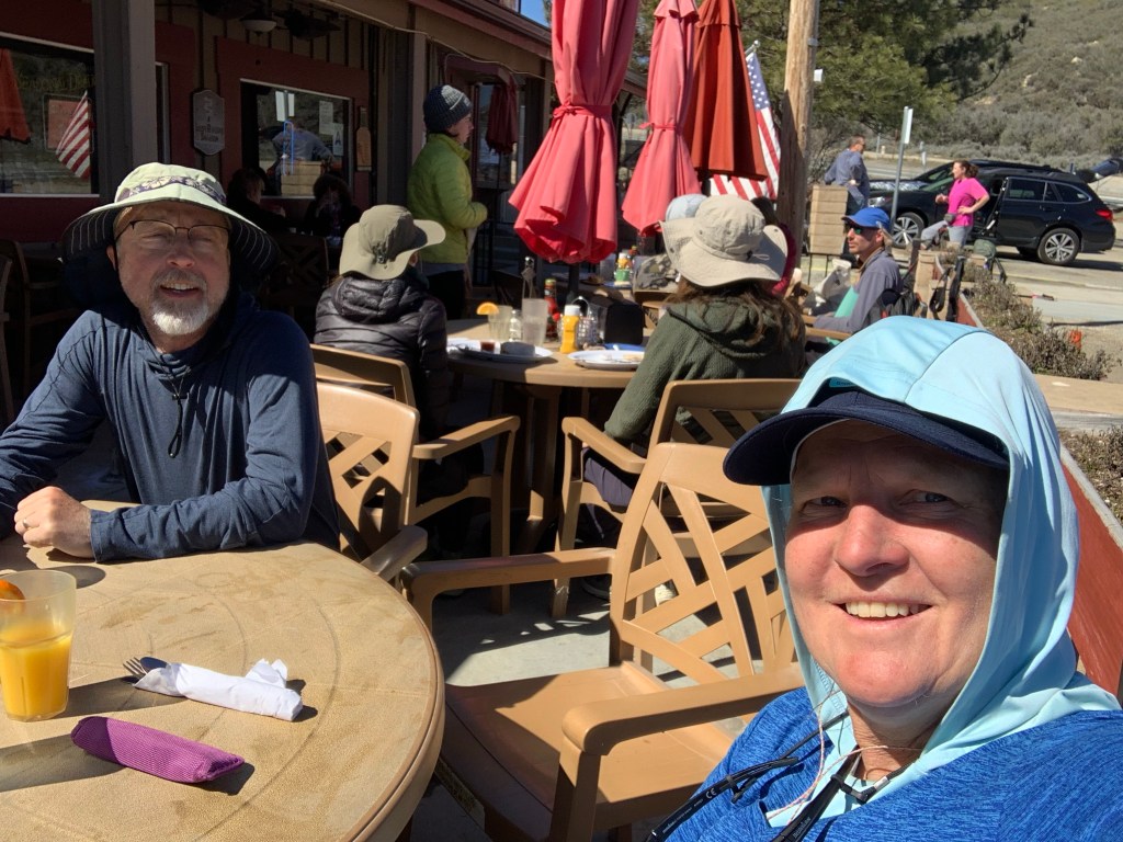
Before we knew it we were at Highway 74 and began the one mile road walk to the cafe. There we reunited with some hikers and met some new ones as well.
Paradise Valley Cafe
The main conversation between all the hikers was about the snow conditions on Mt San Jacinto and the mountains of San Bernardino and San Gabriel. A couple hikers , Trish and Onward, were able to secure a ride all the way to Tehachapi and planned on walking southbound (SOBO) for aa while. Hopefully our paths will cross again.
After we ate our big breakfast we followed up with tall shakes and waited for Ellen’s dad to pick us up.
As we were waiting we were amazed at the kindness of strangers. Frequently local trail angels or just diners would show up and ask hikers if they needed a ride to the town of Idyllwild 17 miles to the north.
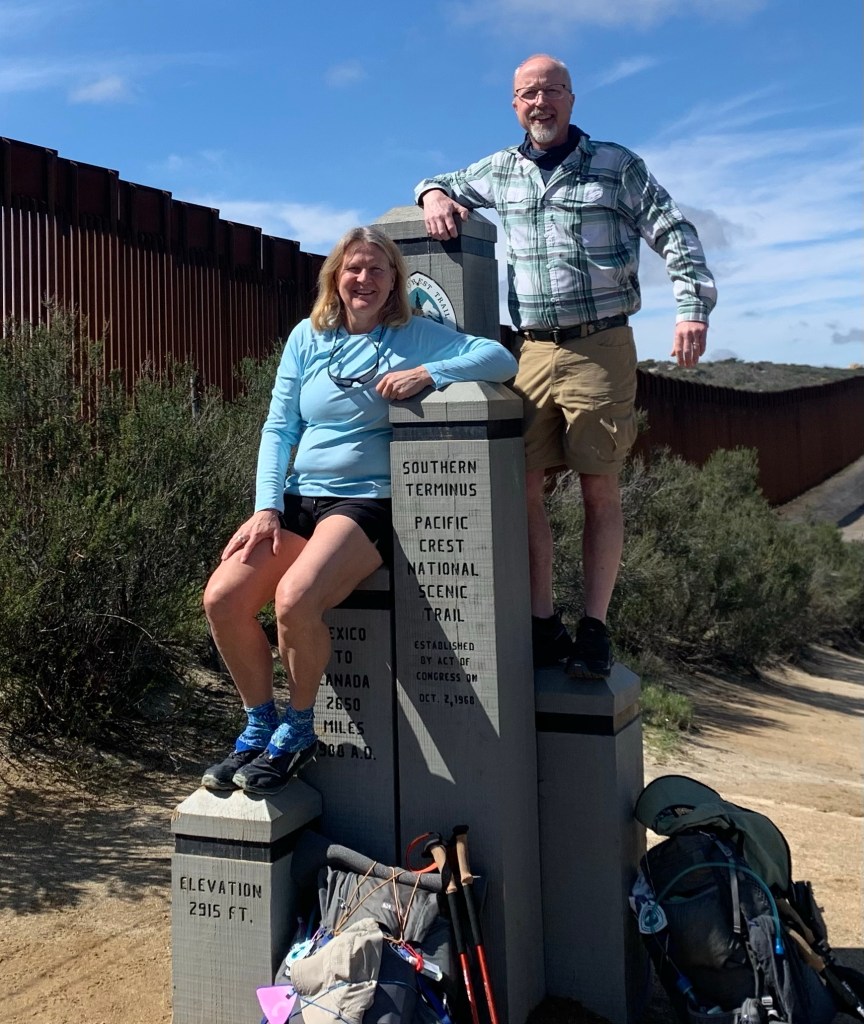
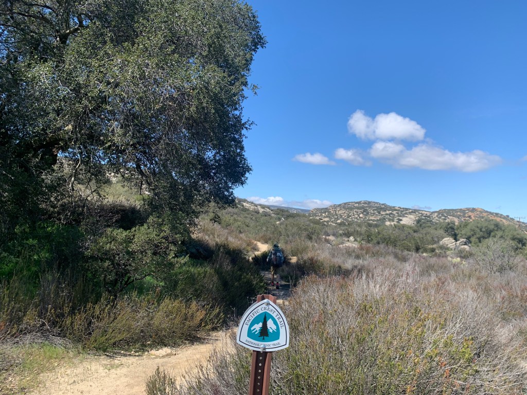
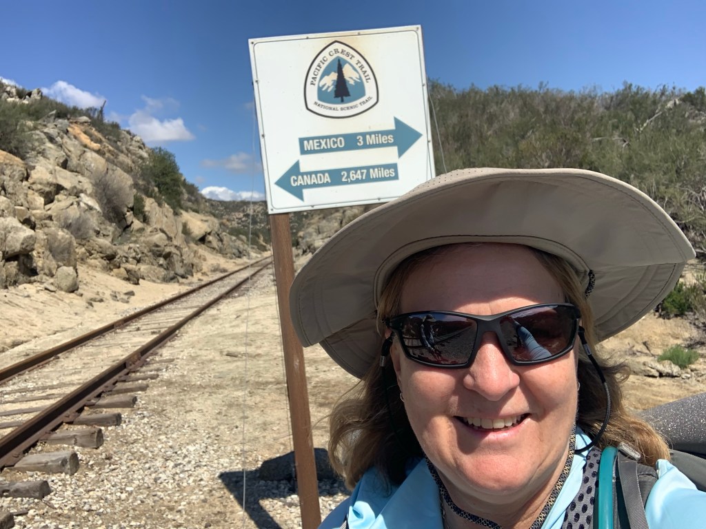
Start time: 12 pm End time: 4:45 pm Start: Southern Terminus – 0.0 End: gate – 8.8 Miles: 8.8 Ascent: 1385 ft | Descent: 869 ft
The day was finally here. After months of planning we were at the Mexican border on the Pacific Crest Trail.
Jeff’s brother Jon drove us to the southern terminus trail head. Just before arriving we stopped in Cameron Corners for some burritos at a taco stand.
At the border we checked in with the PCTA representative who signed our permits and gave us our tags. We posed for some photos at the trail monument and also checked out the border wall. Whether you favor the wall or not, there is no denying that it is both an impressive sight and a scar upon the land.
We started hiking at 12pm and saw surprisingly few hikers. Because of the recent rains, there was an unusual amount of water along this rugged trail.
We were in the tent by 7pm and asleep (more or less) by 8pm. Coyotes were howling and yip yipping around midnight and one was just outside of camp!
Day 2
Start: gate – 8.8 End: view of Lake Morena- 22.3 Miles: 13.5 Ascent: 2228 ft | Descent: 2143 ft
Start time: 7:45 am End time: 4:30 pm
During the evening we noticed an incredible amount of condensation both on and inside the tent. The ground was super saturated and the humidity was extremely high. Then, as morning drew near the temperature dropped just below freezing and it turned to ice. A snow ball formed inside the tent as were shaking off the ice.
A German speaking couple was camped near us and as we proceeded down trail we encountered more hikers along the way. Most of this hiker “bubble” eventually gathered at Hauser Creek to rest and water up before beginning a hot dry climb out of that canyon. Everyone was talking about the iced up tents.
Break time at Hauser creek
We took off before everyone else and we led the way into the small village of Lake Morena where we purchased some more sunscreen and goodies at the malt shop.
Most of the hikers we met earlier decided to stay at the Lake Morena campground. However, we decided to go back on trail for a few more miles.
We stopped at a trickling water to fill up and then walked a mile further to a dry camp on a ridge.
Day 3
Start: view of Lake Morena – 22.3 End: by creek – 36.1 Miles: 13.8 Ascent: 2935 ft| Descent: 1034 ft
Start time: 7:39 am End time: 4:30 pm
A quicker start today, just over an hour! About a mile down from camp we crossed under Buckman Springs Road and our first of two wet foot crossings of Cottonwood Creek.
The trailed wound itself through a valley of some private land. Another mile or so ahead we crossed under Interstate 8 and began climbing up the canyons to the north.
We passed encountered several more PCT’ers as well as quite a few day hikers out to see the flowing creeks and rare water falls on Kitchen Creek. Two such hikers introduced themselves as trail angels and offered us candy bars and tangerines. “Fruit Bowl” as she is known invited us to stop by their camp a few miles ahead for food and beverages.
Fruit bowl, trail angel in training Tacos & Beer, Beer sack
It was 0.7 miles off trail but worth it. This area resembles the location further North where the TV series MASH was filmed. The sun was hot and the was wind cool.
Climbing up to about 5300 ft we found a perfect tent site under a large tree and with a trickle of cool water nearby.
Day 4
Start: by creek – 36.1 End: Garnet Peak jct – 50.1 Miles: 14.0 Ascent: 2054 ft| Descent: 1851 ft
From camp we hiked 6.5 miles up to Mt Laguna over 6000 ft elevation, into the pines and some areas of lingering snow. A week prior hikers were postholing in the snow. Now most of the snow was gone.
We ate lunch at the small restaurant and resupplied at the general store before heading back on trail. Leaving Mt. Laguna we climbed a bit higher onto the ridge overlooking the desert basins and mountains up the east. The view was incredible!
The wind increased into the afternoon and eventually was blowing so hard it could almost knock you over. It also started spitting rain (which was not expected) and so we started looking for a place with some shelter from the wind. Thank goodness we found a small grove of trees below the trail. We set up the tent, unpacked, and made a hot meal. As per usual so far, asleep by 7:30 pm.
Day 5
Start: Garnet Peak jct – 50.1 End: Sunrise TH – 59.5 Miles: 9.4 Ascent: 1082 ft | Descent: 1562 ft
We made great time and the views were again incredible. We were hiking on an east facing ridge with a view of the valley below.
We slept in this morning as we didn’t want to go out into the wind and rain. We finally got going and made great time. The rain pretty much had stopped but the wind was still howling. Last night we check the weather forecast for the next couple days. The forecast had changed with now the major rainfall coming tomorrow. We made plans to go to Julian today (somehow) and get a hotel to wait out the storm.
So many more miles! But one step at a time. Brian (Sunstroke) with Poncho and Maryland
After about an hour we made it to Pioneer Mail picnic area where we met Brian (trail name SunStrokeHiker). He was dropping of his son who was slack packing (hiking without a full backpack). We told him our plans and he offered us a ride into Julian from further down the trail. We exchanged contact info (Garmin and phone) and he said he’d pick us up about 7 miles down the trail or about 3 hours.
Pizza time with hikers Ryan and Becky from Idaho.
Along the way we met a couple from Idaho – Ryan and Becky. They were a few minutes ahead of us and were waiting for a ride into town when our ride showed up. He gave all of us a ride into town and dropped us off at the brewery. We decided to have pizza dinner together and meet up again tomorrow for our “zero day”.
Jeff also made a short video which he posted on YouTube. Enjoy. Here is the link.
As with anything different, there are many words and acronyms distinct that hikers use while on the trail. Here is a short list of the most common used words.
Thru-hiking: and end-to-end backpacking trip on a long distance trail.
Long distance trail: the National Parks defines a long distance trail as a backpacking trip longer than 100 miles.
Trail Angel (TA): anyone who does something kind for a hiker such as providing food along the trail, providing rides to town from the trail head, providing a place to stay, etc
Trail Magic: anything that a stranger provides that is not expected. For example, finding a cooler with cold beverages along the trail, finding a water cache in a remote waterless section of trail, a ride to and from town, etc.
Trail Name: a hiker that is often renamed while hiking with a “trail name.” It is typically more like a one-word description of who he/she is or a funny event that they were involved in. Usually the trail name is given by your fellow hikers.
Tramily: Trail Family – a group of strangers that become friends and end up hiking together and staying in town together.
Town Day: the day on trail when a hiker goes to town for resupply, showers, “real” food, etc.
Zero: typical a day spent in town and zero miles are hiked on the trail.
Nero: hiking less than 10 miles on the trail.
The “red” line: the actual trail as defined by the National Trails system.
Triple Crown: when a hiker completes all three long distance trails: the Pacific Crest Trail (2,650 miles), the Appalachian Trail (2,192 miles) and the Continental Divide Trail (3,100 miles).
HYOH: Hike Your Own Hike. Stay true to what you want out of the hike. Do your own thing if it means losing your hiking friends.
The questions we get asked a lot is what do we do about food? Obviously, we can’t carry all our food for five months. There are several ways to go about food: 1. resupply at each town by purchasing all the food at the local store, 2. send food packages to post offices along the trail, and 3. a combination of 1 and 2. We are opting for the combination of sending and purchasing food locally.
Food Resupply Strategy
We will start of our hike by bringing some of our purchased freeze dried food from home and then purchasing food at local grocery stores along the way. We will be going back to Ellen’s dad after about two weeks and we will again grab some of our freeze dried meals we brought with us. For the remainder of the trail before the Sierra Nevada mountains, we will be buying our food at local grocery stores.
When we get to the Kennedy Meadows at mile 702 (start of Sierra Nevada Mountains), we will have a box waiting for us with our bear cannister, that includes 9 days of food we have prepared at home. Then we will get our food once again at local grocery stores. We needed to put a food box together to see if and how much food would fit into our bear cannisters. Conclusion, we can’t fit 9 days of food into our cannisters. Solution, bring the Ursack for the extra food. We will keep our most “fragrant” foods inside the bear cannister and the sealed food in the Ursack.
The amount of food that we will be carrying depends on location. On average it will be between 3 to 5 days. With longer food carries of 9 days in the Sierra Nevada mountains. There are many towns located close to the trail where we can resupply or if a town is further away, we can find a ride to town. A general rule of thumb to determine how many days to the next town is to take the distance and divide by 15. Fifteen being a good average number of miles per day. This number more than likely will increase as we get stronger or decrease as we slow down when hiking in the snow covered Sierra Nevada mountains.
Types of food
We will be burning a lot of calories and the longer we go, the more we will burn. While on trail, we will be unable to carry enough food as not to lose weight. Thus when in town, we will be eating a bunch of high protein and high calorie food. Can you say lots of pizza, burgers, pasta, etc.?
The food that we will be eating must be relatively high in calorie and protein plus it must be light weight. Food that is heavy contains a lot of of water and water weighs 2.2 lbs per 1 liter. Very heavy. Below is a spreadsheet we created (of course) to determine the number of calories and protein we would consume on a given day.
Typical foods that thru-hikers eat are ramen noodles, instant Idahoan potatoes, Knorr sides (rice or pasta), couscous, a variety of protein bars, chocolate in the form of lots of snickers bars and M&Ms, instant oatmeal or cereal with dried milk, electrolytes, instant coffee, tortillas with tuna packets or peanut butter, other forms of candy and chips. As you can see, not the healthiest diet. But as we get to towns with restaurants, we are going to make a concerted effort to eat some healthy foods to gain back some important vitamins.
One of the hardest and most time consuming item for getting ready for this adventure is gear. Fortunately, we have pretty much dialed in our gear for this trip. We have made some adjustments to lighten the load and also purchased some snow gear. As you’ve read before, we have a major spreadsheet that we use to organize this trip plus to calculate the weight of our gear. As we make changes to our gear we adjust the spreadsheet.
In the thru-hiking world (and backpacking world) the gear is basically divided into two separate categories: base-weight and consumable weight. The base-weight consists of everything that is carried except food and water. Currently, our base-weight hovers around 16.3 lbs each, including the pack itself! This is considered “light-weight”. Incredibly, “ultra-light” backpackers have a base-weight of less than 10 lbs. We have tried to reduce the weight further but there are trade-offs with respect to comfort, safety, and cost and so we are pretty happy with our set up.
The base-weight is then divided into several other categories: the “big 3” (shelter, sleep system and backpack) and then clothing, snow gear, cooking/hydration, and miscellaneous.
The Big 3: shelter, sleep system and backpack
We had been using the Big Agnes Tiger Wall UL3. This is a free-standing tent. With stakes, poles and groundsheet it weighs 47 oz. or 2.69 lbs. The UL3 is relatively small and lightweight but there was room for improvement and so we decided to invest in the Zpacks Duplex tent. The Duplex is a single wall tent which needs our trekking poles for structure. It is made of Dyneema Composite Fabric (DCF), a strong lightweight and waterproof material and weighs in at a mere 25.6 oz. or 1.6 lbs including stakes and Tyvek groundsheet. This almost cuts the tent weight in half!
Both of our sleep systems are basically the same: Big Agnes Q-Core SLX sleeping pad plus Gossamer gear thin-light 1/4 inch foam sleeping pad, Feathered Friends Swallow model 20F down sleeping bag, Cocoon silk sleeping bag liner, eVent compression dry bag and an inflatable pillow. Jeff will be carrying the Big Agnes pumphouse bag for blowing up our sleeping pads.
We both have the Gossamer Gear Mariposa 60L backpack, the Lightheart Gear orange pack cover with hood, and a plastic bag liner. We also each have a pair of trekking poles and a sun umbrella.
Clothing
Hikers generally do not carry more than one set of clothing on their hike. Everyone wears the same thing each and every day. When we get to town, we will do laundry to “clean” our clothes. We will stink, but so does everyone else.
The pictures below are the clothing that Ellen will be wearing and carrying. Starting at the top, a Mission sun hat, sunglasses, a Buff, a sun hoodie, black running shorts, Exofficio underwear, Brooks sports bra, Wrightsocks ankle length socks, Dirty Girl gaiters, and Altra Lone Peak 7 trailrunners. Rain/cold gear consists of a Golite rain jacket, Columbia rain pants, Alaskan fleece shirt, SmartWool Merino beanie, REI liner gloves, Showa waterproof insulated gloves, and a Big Agnes hooded puffy. Other clothing items include an extra pair of socks and underwear, a sleeping shirt, flip flops, and leggings.
Jeff will be wearing the REI Sahara zip-off pants, a Columbia long sleeve button down shirt, Altra Olympus trail runners, Dirty Girl gaiters, Athletic works underwear, Wrightsocks ankle length socks, sunglasses, a Buff, camp shoes, and a wide brim hat. Jeff’s rain/cold gear includes Northface Alta Vista rain jacket, Columbia rain pants, Marmot Zeus puffy, Mammut fleece top, Zpacks Brushtail Possum/Wool beanie, REI liner gloves, and Showa waterproof insulated gloves.
Snow gear
2023 will be a high snow year in the Sierra Nevada mountains. Snow is also expected as we go over Mt. Jacinto around mile marker 165 just west of Palm Springs. We have upgraded our gear by purchasing several items: Katoola K10 hiking crampons, Black Diamond Whippet ski pole, Showa Waterproof insulated gloves, dry socks, winter/snow gaiters, and snow baskets for our trekking poles.
Cooking, water and food storage gear
Ellen will be carrying our stove, fuel and pot. We are forgoing our trusty Jetboil 1L Flash stove and going a little lighter with the Olicamp XTS Aluminum 1L pot and the Olicamp ION Micro titanium stove with a small Bic lighter and a small towel. We will be purchasing along the way the 230 gram or 8.11 oz fuel canister that fits inside the pot. We each have a long spoon. Ellen has the Infinity insulated mug while Jeff has the Sea to Summit X-Seal & Go cup. Jeff will also use a Fozzils folding bowl.
We both have the same system for carrying and filtering water. Two Smart water bottles with a SmarTube hydration tube, a Sawyer Squeeze water filter, and the Cnoc Outdoors Vecto 2L water bag. For extra water carrying capabilities we will each be carrying two Sawyer Squeeze 1L water bags. Ellen will also carry the water tube cleaning brush.
When we get to the Sierra Nevada mountains some extra gear is needs to help protect our food from bears. We each has the Opsack odor proof bags and the Ursack bear bag. Ellen has the Garcia Bear cannister and Jeff has the Bear Vault BV 500 bear canister.
Toiletries, electronics, and first aid
Ellen’s toiletries include a Deuce of Spades trowel, hand sanitizer, Kula cloth, wet wipes, trash bag, and storage bag. Jeff uses toilet paper. There is actually a “backcountry bidet” (essentially a nozzle on a water bottle), but we have yet to try this. Maybe in the future it will save on toilet paper and wet wipes.
We each have the following electronics: iPhone12, Garmin InReach Mini 2, headphones, charger cords, and the Black Diamond headlamp. Ellen will carry a 5,000 mAh battery bank and wall charger, while Jeff will the Renogy 5W solar panel. We used this solar panel on our 2018 John Muir trail hike and it worked really well, especially above the tree line. We each also have a small pocket knife or multi-tool.
Ellen’s first aid / repair gear includes a small hairbrush with hair ties, strips of Leukotape, a roll of precut K-tape, variety of medicines (Ibuprofen, anti-diarrhea, antihistamine, and Mucinex), variety of Band-Aids, Neosporin, nail clippers, tweezers, toothbrush, toothpaste tables, powered soap, Tiger balm, needle w/thread, air mattress patch kit, and extra AAA batteries. Extra bonus gear, Ellen will also carry a bracelet with motivational charms that she got from her friends.
Miscellaneous
Ellen will be carrying the section maps of the PCT by National Geographic, a cork massage ball, reading glasses, small bag with ID, visa card, insurance card, and some cash. Jeff will also have a “wallet” and reading glasses.
Final Tally
As stated above, our base-weight is around 16.3 lbs. As we go into the Sierra Nevada mountains with our snow gear and bear canister, our base-weight will increase to around 23 lbs. With food for up to 9 days and 2L of water, our packs will weigh 41 lbs. However, our packs will lighten up as we eat our food.
Since we decided to attempt to thru-hike the PCT in October and subsequently applied for a permit in November, it has been a whirlwind of planning, upgrading our gear, and dreaming. We were successful in obtaining a permit and secured a start date of March 16, 2023. We will be starting at the southern terminus trail monument near the farming community of Campo, California adjacent to the border wall at the Mexican border. The start of the Sierra Nevada mountains is about 700 miles to the north, and then it’s off to Northern California, Oregon, Washington and finally the northern terminus at the Canadian border. If all goes well, we expect to be on the trail about five and a half months!
There is a lot of planning that goes into a big adventure such as a long distance thru-hike. There are a ton of details to figure out. But as is said in the thru-hiking world, all that planning will go out the window within the first few weeks on the trail. One has to be very flexible and be able to adapt to the conditions that present itself on the trail. However, planning is half the fun and is all part of the journey.
Anyone that knows us, knows that we are both spreadsheet nerds. We have spreadsheets for backpacking gear, canoe tripping gear, mileage for canoe trips, budget, etc. We like to stay organized. So of course, Ellen created a PCT specific spreadsheet. This spreadsheet has about 10 tabs: Ellen gear, Jeff gear, other PCT info, resupply, sierra resupply, on-trail expenses, daily meals, to-do in CA, recipes-cost, and calories. We’ll talk about gear under the gear section.
We added our thoughts to the spreadsheet as we kept thinking about different items related to this hike. Items such as What to do with the house? What to investigate still? Where to send our paper maps and when, postage costs, etc.
Another part of the pre-planning is the training and using our gear. We did an overnight trip in the Superstition Mountains in Arizona over New Year’s Eve to test out our new tent. We also have been going to the gym more frequent to get stronger and up our cardio. However, we do plan to “take it easy” the first couple of weeks and not hike too much each day. We need acclimate our bodies to walking every day.